In 1881 and 1905, two respected Rhode Island history authors made the claim that in colonial times, Godfrey Malbone, a wealthy Newport merchant, had constructed a tunnel from the coastline ending in the cellar to his house, using it to smuggle goods and avoid British tax collectors. This same claim was made in two HGTV home improvement programs, one in 1998 called, “If Walls Could Talk,” and another around 2004, called “Generation Renovation.” Sounds fascinating, but is it true? It is time for some detective work (which brings to mind a more recent PBS series, “History Detectives,” but I have no connection with them).
Certainly, Godfrey Malbone and other Rhode Island merchants had the motive to engage in smuggling. During the colonial period, Great Britain considered its colonies to be subservient to the mother country and wanted to protect its industries and jobs by directing the flow of raw materials from the colonies to Britain. This goal required rules limiting or prohibiting colonial trade with other countries. Between 1651 and 1764, England passed some eleven laws limiting the ability of Newport merchants and other merchants residing in American colonies, from trading outside the colonies.
The Dutch trade with the British North American colonies grew rapidly, so Parliament prohibited all non-British ships from trading in what would become the thirteen colonies. Parliament further required that all cargoes shipped from the British-controlled colonies to Great Britain be transported on ships commanded and manned by British sailors.
The passage of the Sugar Act in 1764 placed new duties on the sugar and molasses imports that Newport and Providence merchants needed for their distilleries. The restrictive trade laws also affected the so-called “triangle trade” involving produce, molasses and slaves, and the West Indies and Africa.
But Newport, Providence, and other Rhode Island merchants became adept at skirting the regulations and beating the system. As the laws were difficult to enforce, because of the very long coastlines and with Great Britain being more than 3,000 miles away, Parliament primarily relied upon the Crown’s colonial governors for enforcement. However, few of them had the interest or the capacity to do so.
Successful merchants, such as Godfrey and Francis Malbone of Newport, took advantage of this situation to engage in smuggling. Francis Malbone became rich enough to build a fine house on Thames Street, and Godfrey built his impressive house just north of Newport near the coastline.
Godfrey Malbone’s house, which measured about 40 feet by 80 feet, was designed by renowned colonial architect Richard Munday and was believed to have been the most expensive in the colony. The grounds of the estate contained 600 acres, stretching from north of the Newport line, past Miantonomi Hill to Coddington Point.[1]
At a dinner party on June 7, 1766, the kitchen chimney of Malbone’s house caught fire. When it was determined that the fire could not be extinguished, Godfrey Malbone ordered the tables moved to the lawn and the dinner finished. Seeing no reason to interrupt the party, Colonel Malbone reportedly said, “If I have lost my house, that is no reason why we should lose our dinners.” The fine mahogany staircase was salvaged and thought to be installed in the Hunter House in Newport, but the rest of the property most likely fell into a state of disrepair.
In 1849, Jonathan Prescott Hall, a New York attorney and descendant of two signers of the Declaration of Independence, built a mansion supposedly on the original foundation of Malbone’s house. Now known as Malbone Castle, it is situated at 90 Malbone Road, about midway between Bedlow Avenue and Cummings Road.
After this time, there are two quotes that suggest that the Malbones had constructed a tunnel used for smuggling in the eighteenth century before the house was burned to the ground in 1766.
Wilfred Munro, in his Picturesque Rhode Island published in 1881, described Malbone’s tunnel as follows:
Persons now living have seen upon the estate Malbone once owned, the entrance to an underground passage which afforded easy communication with the beach, and thus enabled him to elude the vigilance of the custom-house officers.[2]
Mrs. John King Van Rensselaer repeated the story in her 1905 history of Newport:
There was a trap-door in the cellar of the house leading to a subterranean passage, with an opening on the shore where boats could land even at low tide, and there were gruesome tales concerning slaves who were hidden in underground caves, or rooms filled with contraband goods. During the American War of Independence, this hidden passage was used by the spies who were constantly on the watch for all news regarding the movements of the enemy, but this was done so secretly that no written record remains of the dangerous undertakings carried on directly under the eyes of the British.[3]
In 1998, Godfrey Malbone’s reputed tunnel was the subject of an episode from the HGTV series called If Walls Could Talk. In this episode, the owner of Malbone Castle, James Leach, explained that during an extensive renovation of the mansion, he discovered a sealed-off tunnel that may once have been a smuggler’s route to the shoreline.
Careful historians know that claims made in books written in the late nineteenth and early twentieth centuries are sometimes not credible, unless they are supported by corroborating contemporary evidence. I kept this consideration in mind in examining the accuracy of the claims made by Munro and Van Rensselaer.
Godfrey Malbone (1724 – 1785) was the son of Godfrey Malbone, Sr. (1695-1769), who was at one time one of the wealthiest men in Newport due to his involvement in privateering and the triangle trade. He is best known for providing the bulk of the financing for the construction of Trinity Church in 1725 and erecting the original Malbone estate on Malbone Road in Newport.
Godfrey’s cousin, Francis Malbone (1728 – 1785) made his fortune as a shipping merchant at a time when Newport harbor was one of the five busiest commercial ports in the thirteen colonies of North America. He was a colonel in the Newport Artillery Company, which was inactive during the Revolutionary War as a result of its members having divided loyalties. When the British occupied Newport in 1776, they seized Francis Malbone’s mansion at 392 Thames St., which became known as “the treasure house” because it was used to store gold and treasures purportedly looted by the British.
Francis Malbone, as did a number of merchants and ship captains, had his residence on Thames Street, across from the wharves where he docked his ships. When his house was restored in the early 1970s (it was converted to an inn in 1989), archaeologists found a tunnel in the house’s cellar going to the waterfront near Brown Howard Wharf. This discovery provides some circumstantial evidence that Godfrey Malbone had a tunnel at his house north of Newport as well—perhaps the use of tunnels was a family trait.
But other evidence casts doubt on the claim that Godfrey Malbone’s house contained a tunnel to the beach. The quotes by Munro and Van Rensselaer suggest that Godfrey’s tunnel ran straight toward the bay. That would have been a distance of three-quarters of a mile. It is possible that Malbone could have set off secretly at night and had his cargo from merchant ships offloaded onto smaller boats, brought to the shoreline and then carried to the tunnel entrance.
But how likely is it that Godfrey would have spent the huge sums it would have required to construct and maintain a tunnel three-quarters of a mile long? It would seem that the large cash outlays required would have dwarfed the relatively small amount of taxes actually imposed by British authorities. Thus, I believe it is unlikely that such a long tunnel would have been built.
If Godfrey had built such a long and impressive tunnel to his property, it seems likely that it would have been mentioned by contemporary diarists and letter writers. But I am not aware of any such mention.
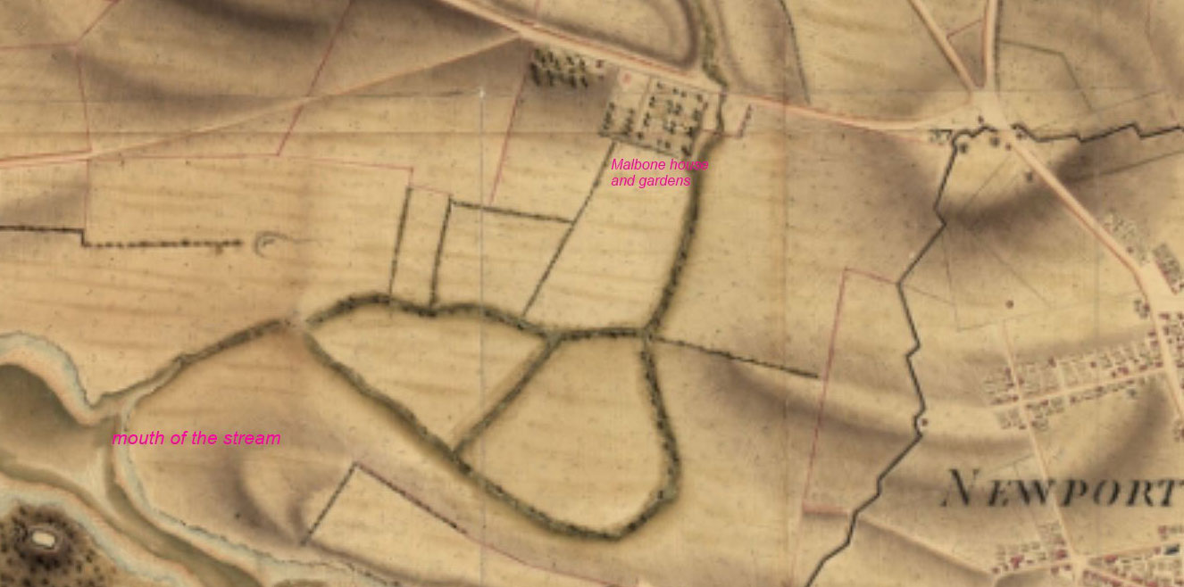
Another possibility is evident. Under cover of darkness, Godfrey Malbone could have brought his smuggled goods to the coast opposite Coaster’s Harbor Island and loaded them onto smaller flat-bottomed boats. These boats could have been guided up a stream opposite Coaster’s Harbor Island that flowed east and toward Malbone’s house. With their shallow drafts, they could have avoided running aground in the stream, which ran under Malbone Road near its intersection with Smith Avenue. The boats could have stopped at a spot on the border of Malbone’s estate and then could have been offloaded into a tunnel that led to the house. The formal gardens, in the rear of the house, skirted the stream for about 500 feet. Today, much of the stream has been filled in, but there are some areas where it is still visible.
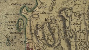
Two contemporary maps show how the stream that could have been used. One, prepared by British mapmaker Charles Blaskowitz in 1777, showed the stream flowing more north-south than east-west. It also placed the Malbone house slightly north of Dyer’s Point and the Battery (Battery Park). [4] Another map, a French one drawn in 1780 probably by cartographer Louis-Alexandre Berthier, is more accurate, showing known reference points and geographical features in greater proximity to their existing counterparts. This map places the Malbone house three-quarters of a mile northeast of where the Blaskowitiz map puts it. [5]
Although not labeled by Berthier, Godfrey Malbone’s property is indicated by the rectangle in the upper center of the detail of the map shown here. The house was located in the upper left corner of that rectangle. The formal gardens occupied the southern and western portions of the rectangle. The mouth of the stream is clearly visible opposite Coaster’s Harbor Island and its path (the dark lines curving through the center of the image) can be clearly seen to pass by the Malbone estate. The stream bed is about one hundred feet from the border of Malbone’s gardens.
But why would Malbone have constructed a tunnel on the stream-side of his property? If his sailors could have brought the goods up the stream and close to his property, it seems that they could have easily carried the goods by hand overland to Malbone’s property. That would avoid the great expense of building a tunnel.
Van Rensselaer’s claims that Malbone’s tunnel was used by spies during the American Revolution, to smuggle slaves, and play a role in the Underground Railroad freeing slaves, seem dubious at best. I spoke about this claim to Christian McBurney, author of the recent Spies in Revolutionary Rhode Island. McBurney said that his research did not reveal any contemporary mention of the use of tunnels for spying. He strongly believes that if an active tunnel had existed, it would have been discovered by the British army when it occupied Newport between 1776 and 1779. He also pointed out that Godfrey’s house had burned down in 1766, so it was unlikely that any tunnel would have been in usable condition ten years later.
Authors Munro and Van Rensselaer, writing in 1881 and 1905, respectively, could not have known of any person who had direct knowledge of a tunnel built by Godfrey Malbone in or before 1766. They must have heard stories that were passed down by generations of Newport storytellers. Frequently, such stories are partly, but not entirely, true. It is possible in this case that the stories were originally about Francis Malbone’s tunnel on Thames Street, and somehow over the years the Malbone name was changed to Godfrey.
My best judgment is that Godfrey did not build a tunnel to the shore. It would have been too expensive. This also suggests that the finding in Francis’s house on Thames Street was not a tunnel either. Why would he have needed a tunnel when he could have more easily used one of the many nearby wharves? In both cases, the openings could have been cellars intended as additional storage space to keep their products cool and as well preserved as possible. Or the space could have indeed used to store and hide smuggled goods. It would likely take professional archeological work to determine if either Godfrey or Francis did build a tunnel to the shoreline.
Eventually, the smuggling engaged in by Malbone and other Rhode Island merchants became a flashpoint that led to the Revolutionary War. Merchants did not want their profits reduced by taxes and rules imposed on them by a far-away Parliament, while Royal Navy warships arrived in Narragansett Bay in 1763 to patrol to catch smugglers. The animosity engendered by their presence and the enforcement of the Navigation Acts, which required stopping, searching and seizing vessels, caused frequent quarrels in Newport streets. The rioting that occurred in Newport led to support for the rebellion and ultimately the Revolutionary War. By war’s end, smuggling was not needed to profit from commercial maritime activities, and any tunnels that might have been built would have fallen into disuse and disrepair.
[Banner Image: Map drawn in 1780 probably by Frenchman Louis-Alexandre Berthier (Library of Congress)]
1. Maud Howe Elliot, This was My Newport (New York, NY: Arno Press, 1975), p. 13.
2. Wilfred H. Munro, Picturesque Rhode Island (Privately printed, 1881), p. 39. Also quoted in May King Van Rensselaer, Newport: Our Social Capital (Salem, NH: J.B. Lippincott Company, 1905) (reprinted 1990), pp. 297-298.
3. Mrs. John King Van Rensselaer, Our Social Capital, p. 298. Also quoted in D. K. Abbass, Rhode Island in the Revolution: Big Happenings in the Smallest Colony (USDI National Park Service, American Battlefield Protection Program, 2006), pp. 399-400 and Elaine F. Crane, A Dependent People: Newport, Rhode Island in the Revolutionary Era (New York, N.Y.: Fordham University Press, 1985), p. 86.
4. A topographical chart of the bay of Narraganset in the province of New England, with all the isles contained therein, among which Rhode Island and Connonicut have been particularly surveyed, shewing the true position & bearings of the banks, shoals, rocks &c. as likewise the soundings; To which have been added the several works & batteries raised by the Americans. Taken by order of the principal farmers on Rhode Island. Charles Blaskowitz. London] Engraved & printed for Wm. Faden, 1777. Available at the Library of Congress.
5. Plan de la position de l’armée françoise autour de Newport et du mouillage de l’escadre dans la rade de cette ville, 1780. Available at the Library of Congress. This unsigned map was apparently made in the autumn of 1780. Some smaller versions of this same map have the signature of Colonel Desandroüins of the Royal Corps of Engineers. The Library of Congress version does not attribute an author. While the map may have been prepared under Desandroüins’s direction, it is very likely that it is one of Louis-Alexandre Berthier’s maps because of similarities in style and technique with other known Berthier maps. Berthier was Count de Rochambeau’s aide-de-camp and main cartographer.

