[From the editor: A wonderful recent trend in the Rhode Island history scene has been the placement of historic markers in towns across the state. Historic markers bring back to life the history of towns in a publicly accessible way, often in areas where historic buildings still exist. An impressive recent historic marker project was just completed by the town of Richmond, which placed historic markers on the Richmond Heritage Trail (on Country Acres Road, across from the Meadow Brook Golf Course). As explained below, inspired by Wickford, the village of Lafayette recently completed a historic marker project. East Greenwich also completed a historic marker project that will be the subject of a future article. Wilcox Park in Westerly and the East Bay Bike Path have long had fine markers, as have the cities of Newport and Providence. (If you are aware of other towns doing the same, please let me know.) The hope is that these articles will inspire other towns and cities to do their own historic marker projects. In this article, Mike Donohue and Tim Cranston (North Kingstown’s terrific historian) explain how Wickford’s ground-breaking historic marker project was accomplished. The main driver of the project was Historic Wickford, Inc. (“HistWick”), a nonprofit organization whose mission is to preserve, protect and celebrate historic Wickford village.]
How did the Historic Marker Project come about?
The initial idea for the project started in 2010 as an offshoot of Tim Cranston’s four book series on the history of Wickford. Historic Wickford recognized the value of such a project and the local Historic District Commission was also in favor, but funds were not available at that time. The project was reborn in early 2015 when Town historian Tim Cranston and Planning Department employee Shaun Lacey developed a grant application on behalf of HistWick to the Rhode Island Foundation for funding for six markers. The application was successful and $6,000 was awarded for the initial project. HistWick also agreed to provide $5,000 toward the project for a total of $11,000 to cover the total cost.
The project planning started in the summer of 2015, following up on historic signage ideas proposed by other groups in prior years. This project was a Historic Wickford, Inc. (HistWick) initiative and HistWick board members and other Wickford citizens sat on the committee which started to meet monthly to make the project a reality. The initial committee members were Art Hall, Sue Moore, Pete Galster, Mike Donohue, Linda Piedra, Larry Ehrhardt, Charles Bauer and Tim Cranston. Charles Bauer and Mike Donohue were co-chairmen for the project.

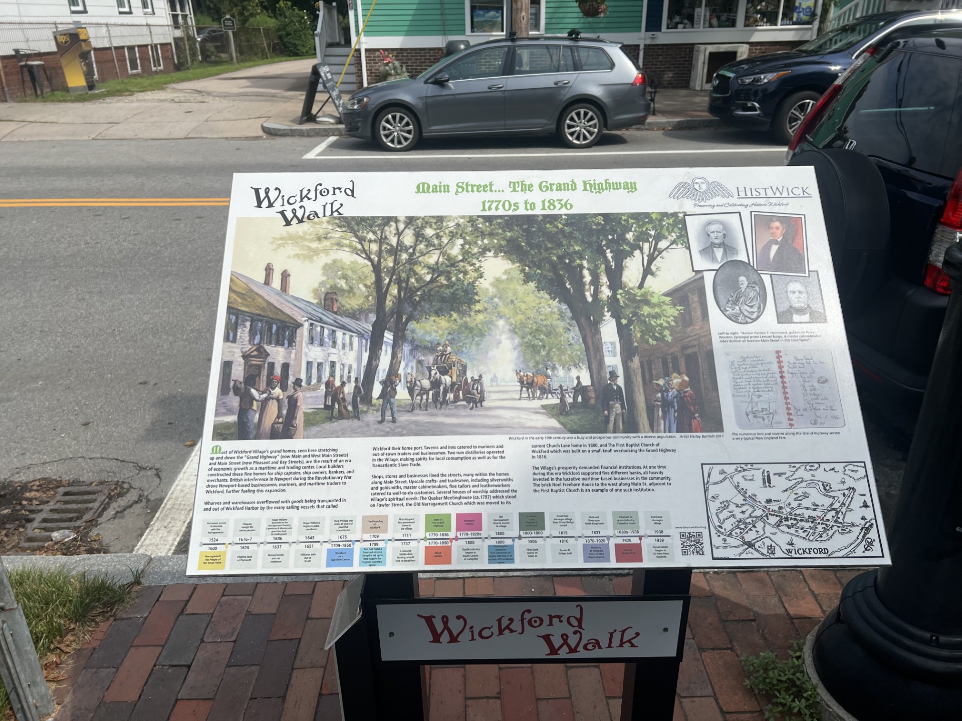
The historic market titled Main Street—The Grand Highway, 1770s to 1836. Men and women who are white and who are of color appear in the painting (Christian McBurney)
What were the Goals of the Project?
We wanted to find a way to develop markers/signage that would focus on diverse topics over the eras of local history, from the time of the Narragansett settlements in the area through the beginning of the 20th century. Topics that would highlight historic, cultural, social, industrial, and commercial developments in Wickford that would be of interest to residents and visitors alike.
We also hoped to ensure that all peoples involved in the development of the community, men and women, would be recognized and known to be part of our history, first through a marker illustrating the eras when the Narragansett people lived in our area of Rhode Island, then known as Cocumscussoc, and then including a marker discussing the positions of freed African American sailors who sailed out of Wickford on merchant ships in the years before the Civil War and served in other roles in commerce, culture and trade as well.
How did you decide how many markers to do and on what topics?
We knew that with careful planning our budget would cover the costs of writing the text and producing the five markers. Town Historian Tim Cranston developed a list of five appropriate periods of history to cover including:
The Narraganset—The People of the Small Point
The Founding of Wickford, Pleasant Street
Wickford as a Maritime Center, Early 1700s to 1860s
Main Street—The Grand Highway, 1770s to 1836
Wickford, Gateway to Newport from 1870 to 1920s
We also produced a marker placed in Updike Pike in the center of Wickford with a map showing the locations of each of the other five markers and a concise summary of village history. At the central marker, maps of the sites of the markers are also available.

The historic marker titled Wickford, Gateway to Newport from 1870 to 1920s. A part of Wickford Harbor is in the background (Christian McBurney)
How were you able to have original paintings done of street scenes? What were your goals here?
Obviously, no photographs would be available to cover many of the topics we would want to cover for the earlier periods of our history. Tim Cranston came to the rescue again, suggesting contacting several artists to provide appropriate illustrations for each marker. For the Narragansett marker we were truly fortunate that Dawn Spears and Angel Smith, members of the Narragansett nation, provided paintings of what a traditional Narragansett summer village along the Wickford coastline would have looked like. That marker is located on Bush Hill to the north of the junction of West Main Street.
For the marker on Pleasant Street facing Lodowick Updike’s home, and to provide an idea of the wharves extending into the harbor from the back of that property in the 18th century, Lorraine Bromley provided the illustration of both the existing home and the ships that would have been seen at this location hundreds of years ago.
For the marker on West Main Street along Academy Cove, local artist Donato Beauchaine developed a painting showing how ship hulls would have been built inside the cove, which then would have been floated out into the harbor to be fitted with masts as the last step before they began sailing.
The illustration on the importance of Main Street as a financial and commercial center in the latter half of the 18th century and into the 19th century was painted in oils by Harley Bartlett, a well known Rhode Island artist who used a post card depicting mid-19th century Main Street as the initial design, adding in figures that would have been typical in dress and style for the period.
The fifth and final illustration of the first round of markers described how a rail spur was built from the Wickford Junction rail station to the port of Wickford so that wealthy travelers could board private rail cars to take the short train ride to ferries in Wickford that would then carry them to Newport in style, reducing the travel time required to go all the way to Providence and then back down the eastern side of the bay. For this illustration, Deborah Sabo, our graphic designer used a “birds-eye” illustration of the village of Wickford as well as a custom map of the streets and avenues of Wickford to denote the path of the train.
All the artists were paid for their work. Four of the artworks were kept by HistWick, which retained the right to use the illustrations for ancillary materials including prints and notecards. Over the last year, the four original paintings that we owned were given to the Town of North Kingstown, where they now are mounted on the walls of the newly renovated North Kingstown Town Hall on Boston Neck Road.
After the initial five markers were installed to considerable acclaim, an additional seven markers were funded, created, and installed by HistWick to further awareness of additional areas of interest in the community. An example of the topics for these subsequent markers included: How Ten Rod Road served as a seventeenth- and eighteenth-century road to transport livestock from eastern Connecticut and western Rhode Island to the port of Wickford for transport to the southern American colonies and the Caribbean islands. Local resident Dan Urish was the artist responsible for the illustrations on this marker.
A marker sponsored by the Rhode Island Department of Transportation (RIDOT) recognized the Hussey Bridge constructed in the 1920s as a unique type of bridge design by Clarence Hussey, the first RIDOT Bridge Engineer.
The Rhode Island Department of Environmental Management (RIDEM) funded a marker to celebrate the Narragansett Rune Stone, now prominently displayed in the middle of Wickford.
After our efforts, residents of the Lafayette village of North Kingstown created their own series of markers using the Wickford marker concept focusing on the importance not only of small-scale textile production in South County but also the region’s sad connections to the Negro Cloth business.

The Central Marker, located at Updike Pike in the center of Wickford, with a guide to the first five historic markers in Wickford (Christian McBurney)
Who wrote the text of the markers? Was it vetted by anyone?
The initial texts for the markers were provided by North Kingstown Town Historian Tim Cranston and reviewed by the marker committee. Tim’s intricate knowledge of local history gave us a powerful base for all our efforts.
Would you like to add anything else that readers should know about the Project?
The project took several years to complete as the committee members worked on determining the site for the markers and obtaining approvals for the project from the Town Council. The markers and sites were also reviewed by and approved by the local Historic District Commission and by the board of Historic Wickford. There were several drafts of the text and artwork for each marker during the review process, all studied for accuracy by the graphic designer and committee members before final approval was given.
The markers were manufactured by Fossil Industries of Deer Park, New York, which also produced of the markers on the East Bay Bike Path on the other side of Narragansett Bay.
The unveiling ceremony was held on Saturday, April 7, 2018, in Updike Park where the artists were recognized for their work and the community celebrated this effort to make residents and visitors aware of the history of Wickford Village.
Due to the success of this initial effort, we were asked to produce additional markers to illustrate sites of historic importance in Wickford and six more markers were developed, with the guidance of Tim Cranston and Deborah Sabo, to further enhance awareness of our heritage. The markers are now part of what is called “The Wickford Walk” with brochures (as well as online resources through HistWick (https://histwick.org/)) that are available to guide visitors to each site.
“The Wickford Walk” also became the subject of a thirty-minute video documentary produced by Charlie Weber that was shown on Rhode Island Public Television in the summer of 2019. The video included a carriage tour of the streets of Wickford highlighting each marker. There was aerial drone footage of the village emphasizing how the waterways throughout the village were (and still are) intrinsic to village life. All the artists were interviewed about their experiences as part of the project. Angel Smith noted that, in producing the artwork on the marker detailing Narragansett life before the colonists, she was proud that a Narragansett native worked on it, as “we don’t always get the chance to tell our own history.”
The program is available on YouTube at https://www.youtube.com/watch?v=gJstHN8f56I&t=2s.
Finally, at the end of 2019, Historic Wickford, Inc. was awarded a coveted Rhody Award from Preserve Rhode Island, the state-wide historic preservation organization whose mission is to protect and activate historic places for the benefit of all Rhode Islanders.

The historic marker titled Wickford Walk, Story of Ten Rod Road. The painting shows cattle being driven on Ten Rod Road to the port of Wickford (Christian McBurney)
Nine years after the initiation of the project, and seven years after the installation of the markers, we remain thrilled when, either walking or driving through the village, we see people stop at the markers to learn about our village’s history. It is a recognition of significant efforts made by many local residents for the benefit of our larger community.


