

In last week’s article, I listed my top ten most interesting and amusing street names in Rhode Island. This article includes a list of fifteen honorable mention most interesting and amusing street names; 8 great street names that have disappeared; 5 interesting groupings of street names; and 2 insensitive street names.
The names of the persons who provided me with the idea for the name and related information are provided. This is my list; you may have a different one!
This article does not include streets named with Narragansett tribe or other Indian names. Those deserve a separate article
Enjoy! And, again, please do not steal any of these street signs!
Honorable Mentions (in alphabetical order):
Benefit Street (Providence). The road in an old section of College Hill was a public road constructed for “the benefit of all.” (Norm Desmarais)
Biscuit Hill Road (and Biscuit Hill) in Foster supposedly got their names when Count de Rochambeau’s French army was marching from Newport to New York in June 1781. A wagon broke a wheel and overturned on its way to the Waterman’s Tavern camp, spilling biscuits along the road. (Norman Desmarais)
Butterfly Way (Lincoln). It is a modern street a little west of Great Road. It gets its name from the Butterfly Mill which was located where Great Road crosses the Moshassuck River. The mill had two stones shaped like butterfly wings in one of its walls. Alterations in the 1950s reduced the mill from two stories to one. It is now a private residence and the butterfly stones are set in the chimney. (Norman Desmarais)
Dreadnaught Avenue (Bristol). This street is located west of Hope Street and is off of Mulberry Road north of downtown Bristol. Of course, Bristol was the home of the famous Herreshoff shipbuilding company, which was particularly renown in the late 1800s and early 1900s. And to the south was the Naval War College. Herreshoff built some torpedo-launching ships for the U.S. Navy in the early 1900s. A dreadnought was the first large battleship armed with massive heavy-caliber guns. The British launched the battleship Dreadnought in 1906. The United States followed with its own. This could have been the derivation of the street name (although it is spelled with an “au” rather than an “ou”). (Christian McBurney)
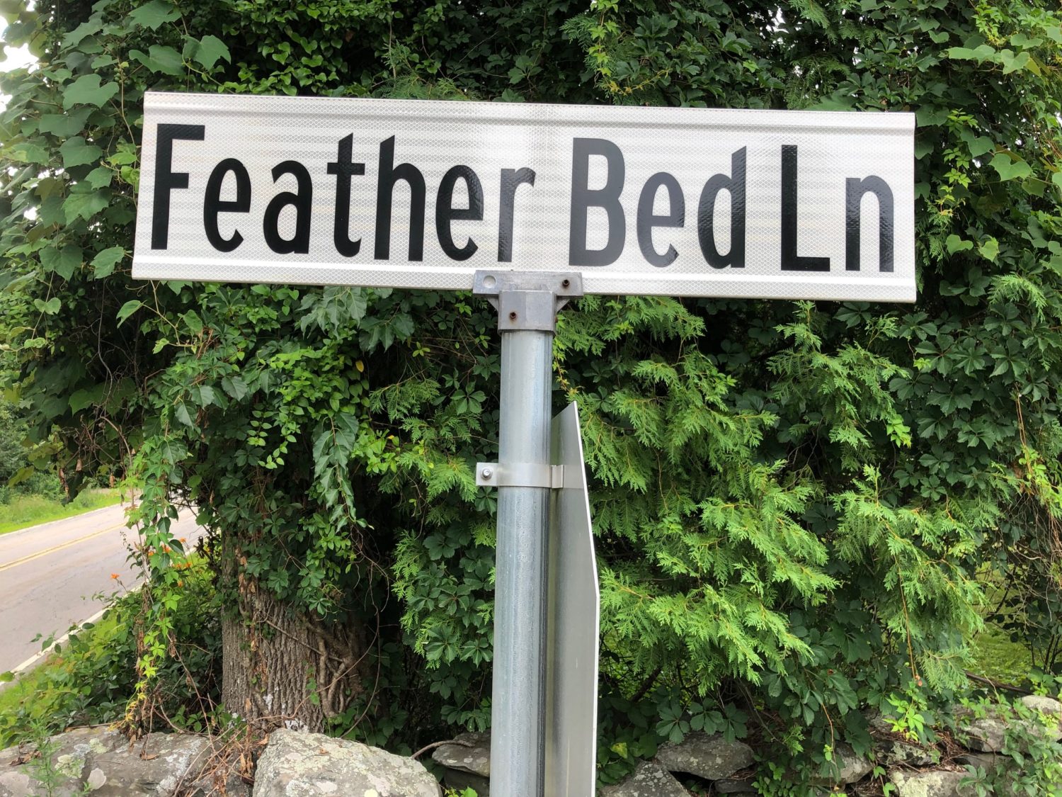
Featherbed Lane (North Kingstown). It is short road that connects Hamilton Allenton Road with Annaquatucket Road a couple of hundred yards west of Boston Neck Road (Route 1A) west of historic Hamilton village. The site of the ruins of what once was a water powered mill along the stream feeds the large pond immediately west of Boston Neck Road also feeds the little pond with all the huge water lilies on the east side of Boston Neck Road. Also on that short road is the Stephen Northrup House at 99 Featherbed Lane that may be the oldest one in North Kingstown. (Michael Donohue, President, Histwick)
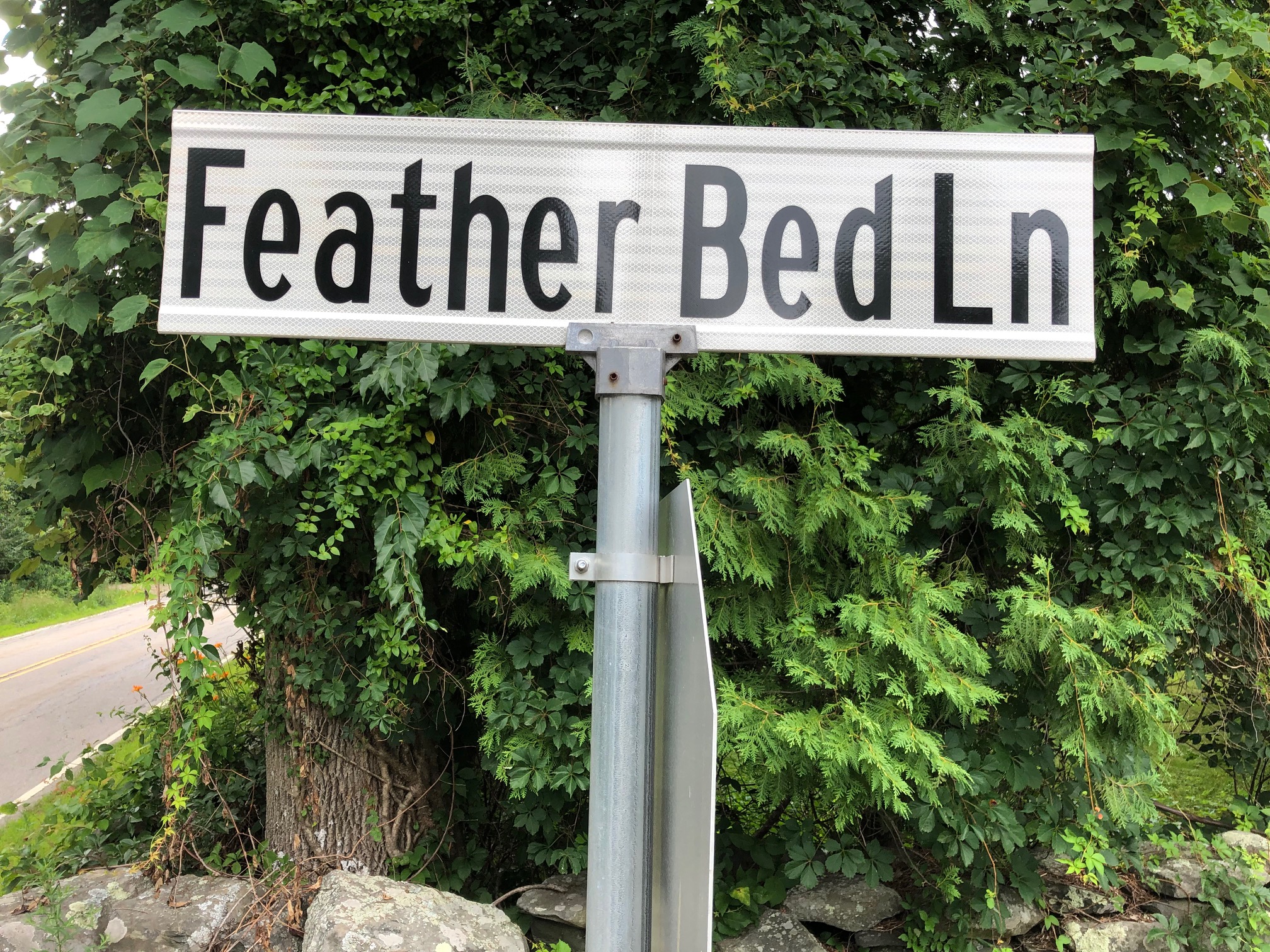
Featherbed Land is spelled here using two words, but the author believes it should be one word. In doing this article, the author appreciates that the issue of one-word versus two-word street signs is prevalent. (Christian McBurney)
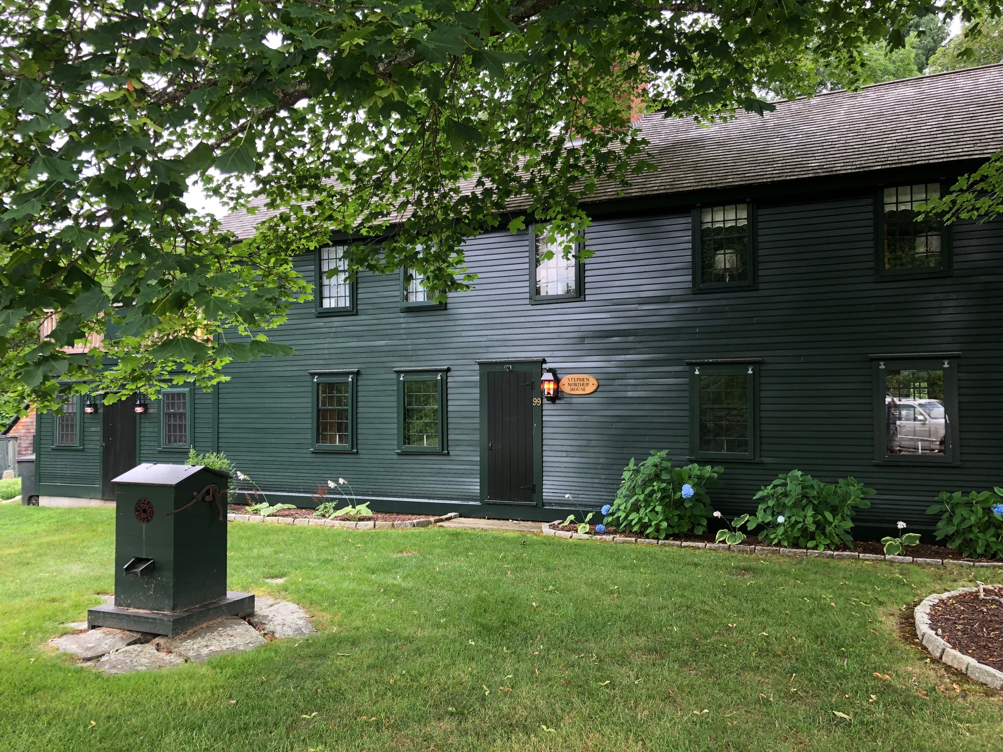
The Stephen Northrup House at 99 Featherbed Lane. Dating back to the 17th century, it may be the oldest house in North Kingstown. (Christian McBurney)
Leonard Jenard Drive (Pawtucket). It rhymes! An article on the web listing the funniest street name in each of the 50 states came up with this one for Rhode Island for that reason. It is included only because it was on that list. The author of that article displayed a pretty weak effort, in light of the examples above and since it is poking fun at an individual’s name. The Jenard name originally was French and pronounced “Genod.” By anglicizing the name, it rhymes. The road is off of Weeden Street near Route 122. (Christian McBurney)
Little Rest Road (Kingston). The village of Kingston used to be named Little Rest and Kingston Hill used be known as Little Rest Hill. Now all that remains of the name is Little Rest Road, off Kingstown Road (Route 138) a short way down the hill to the west of Kingston. The colonial origin of the Little Rest name is not known. One story is that when court was in session at the King’s County (later Washington County) court house, the village became so crowded that no one could even get a little rest. But the name of the town predates the removal of the court house from Tower Hill to Little Rest in 1754. Another story is that when the Massachusetts, Plymouth and Connecticut white soldiers marched to the Great Swamp to attack the palisaded fort of the Narragansetts in December 1675, they stopped here for a little rest. Let’s change Kingston’s name back to Little Rest! (Christian McBurney)
Nooseneck Hill Road (West Greenwich, Coventry, etc.). Nooseneck Hill is in West Greenwich in the Big River Management Area. Now part of Route 3, the road starts in Coventry at the corner of Tiogue Avenue and Reservoir Road in Coventry. It extends into West Greenwich, Richmond, Exeter, and Hopkinton. Sidney Rider, an important Rhode Island historian of the late 19th century, says the following about the derivation of the name. “The word Nooseneck is said to have derived from the setting of running nooses for catching deer in Nooseneck Valley. . . . [T]his explanation is, of course, nonsense. . . . The tract of land designated by the name Nooseneck is a narrow neck lying between two small streams, which unite and become a tributary to the Pawtuxet. As you approach the sources of these streams, the land rises to a considerable height, and is known as Nooseneck Hill. The narrow neck, which consists of the lands through which the streams flow, is an exceedingly beautiful valley. The name Nooseneck is affixed to this locality on Benoni Lockwood’s map of Rhode Island, made in 1819 …” Rider goes on to say that he believes the name derives from a corruption of the Narragansett Indian term “noosup,” which means beaver pond. “The small rivers with their beautiful valleys became the home of beavers. The sites of their dams are very numerous. Hence the locality became known as “Noosup Neck,” corrupted as we now see it.” (Christian McBurney)
Paradise Avenue (Middletown). Paradise Avenue was named for the tranquil setting in Paradise Valley leading to Sachuest Point National Wildlife Refuge. It is where the famous Irish 18th century philosopher, Dean Berkeley, wrote his Minute Philosopher on top of Hanging Rock. Paradise Valley was also a favorite setting for 19th century painters such as John Frederick Kensett and John LaFarge. According to a history of Newport County, Paradise Valley was named by Isaac Barker, who was a prominent Patriot spy during the American Revolutionary War. It is odd that Paradise Avenue is so close to Purgatory Road! (Russell DeSimone)
Poverty Corner Road (Warren). Poverty Corner Road is in Warren, running between Schoolhouse Lane and the Swansea, Massachusetts border. The origin of its unusual name is not known. Bob Coyne wrote me: “As part of the removal of the Bristol County Water Authority dam, the lower Kickemuit Reservoir was removed. That reservoir lied south of Poverty Corner Road. Poverty Corner Road continues in Swansea as Bushee Road, which runs between Route 6 and Old Warren Road. I’m not sure whether the intersection on Route 6 was the “Poverty Corner” or whether it referred to its intersection with Old Warren Road. The 1895 map of Swansea (Everts & Richards, Historic Map Works website), long before the GAR Highway was built, refers to Bush Rd, not Bushee Rd. But the 1870 map of Warren (D.G Beers & Co.) refers to the C.J. Bushee house on the Old Warren Road, just westerly of what is now Poverty Corner Road. According to the April 1975 State Preservation Report on Warren, the Benjamin Bosworth House, begun in 1690 by John Cole, stood on Poverty Corner Road; it must have been torn down after 1975. The Bosworth house is shown on the 1870 map just over the state line, in Warren.” (Bob Coyne).
Punchbowl Trail (Richmond). After proceeding up Punchbowl Trail from Old Usquepaugh Road (opposite Kenyon’s Grist Mill in West Kingston), one enters a natural formation that has the appearance of a punch bowl. Down below is a swampy area divided by the road. Then the road heads back up an even larger hill. Thus, the punch bowl effect. The swamp has been the home of a busy beaver that has tried several times to block the culvert leading under the road, succeeding several times in flooding the road. State authorities appear to have resolved the issue without having the destroy the busy beaver, whose hut is nearby. To the north, this road is intersected by Small Pox Trail. Beyond that, a Punch Bowl Academy (a private school) appears on Punch Bowl Lane in Walling’s 1857 map. (Christian McBurney)
Rocket Street (Westerly). This street’s name was in existence at least by 1902, well before Robert Goddard sent the first liquid-fueled rocket aloft at Auburn, Massachusetts, in 1926. Congreve rockets powered by gunpowder were used as a weapon of war by the British in the late 18th century and early 19th century, including at Fort McHenry in Baltimore (see “the rockets’ red glare” in the Star-Spangled Banner). The word “rocket” has an even longer history. The street is off of Granite Street in Westerly. (Christian McBurney)
Scrabbletown Road (North Kingstown). Scrabbletown, in the hilly, stony, northwest part of North Kingstown, was said to have been so named because the people who resided there had to “scrabble” for a living (that is, they had a “hard-scrabble” existence). The word “scrabble” means too scratch or scrape, as with the claws or hands. Scrabbletown Road starts on Quaker Lane (old Route 2) south of Stony Lane and ends at Old Baptist Lane near the intersection with Ten Rod Road (Route 102). (Alexander A. McBurney)
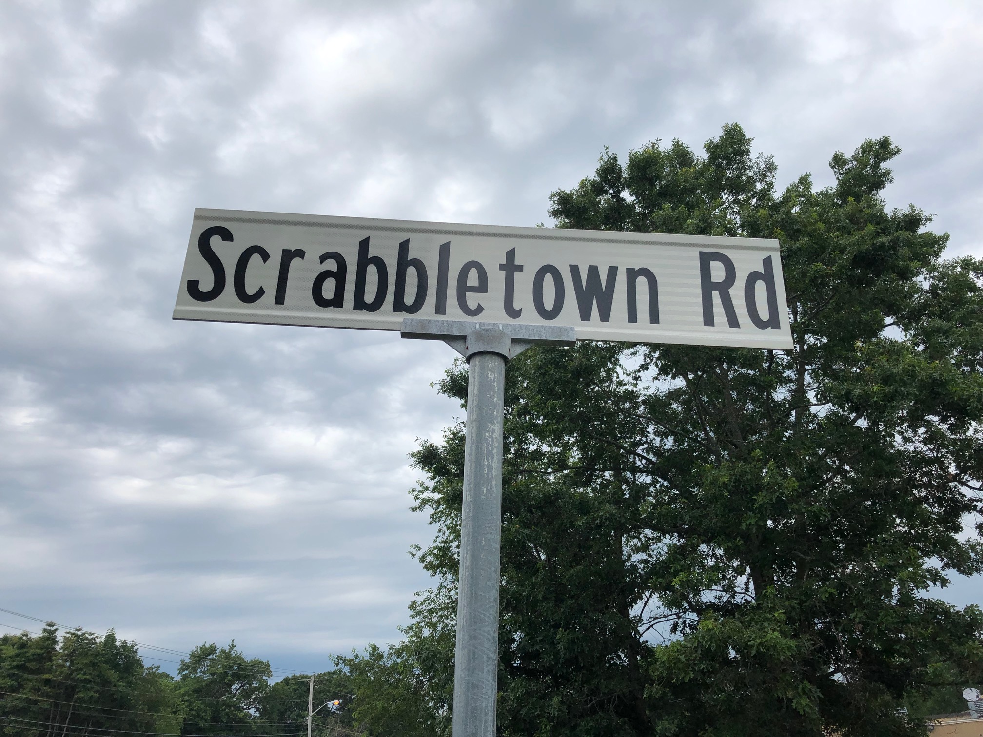
Scrabbletown Road in North Kingstown near the border of Exeter (Christian McBurney)
Steamboat Avenue (Wickford). This lane originally was part of a 3.5-mile spur railroad line for the Newport & Wickford R.R. and Steamboat Line, starting from the station stop at Wickford Junction and proceeding down to the pier (called Wickford Landing) where waiting steamboats would ferry passengers to Newport. During the Gilded Age, this route was a favorite one for New York’s elite to reach their mansions on Newport’s coast. The operation began in 1871, with the steamboat Eolus making the runs to Newport. In 1889, it made three round trips daily. In 1907, the rail and steamboat operation was taken over by the New York, New Haven and Hartford Railroad. The General was an ornate and well-liked steamboat, which even offered a brass band for the hour long ride to Commercial Wharf in Newport. It operated until 1925, when the entire service ended. Steamboat Avenue now ends at aptly named Newport Avenue. (Brian Wallin).
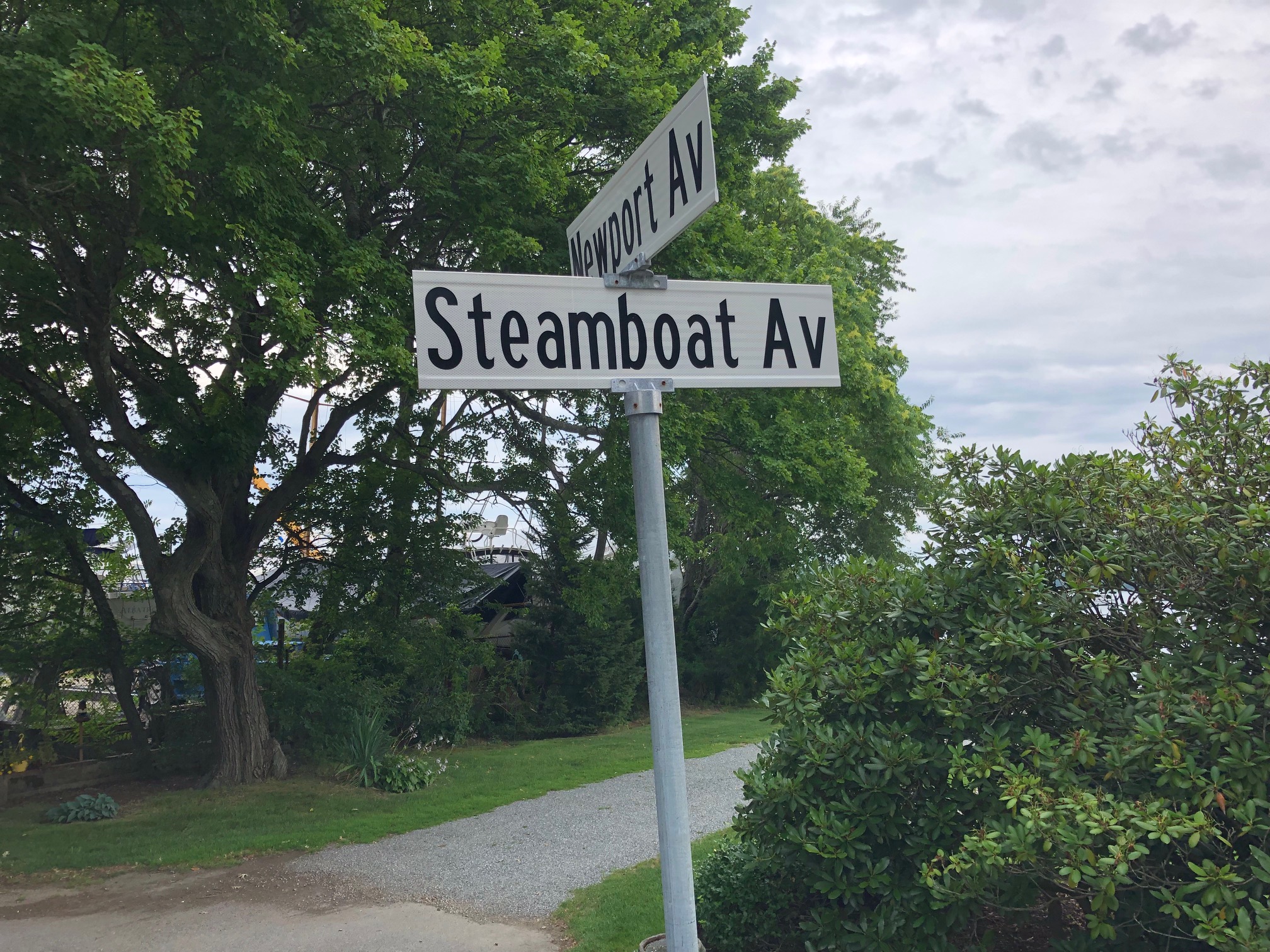
This view of the end of Steamboat Avenue shows a small road that led to a wharf for steamboat passengers traveling to Newport (Christian McBurney)
Wapping Road (Middletown, Portsmouth and Bristol). What is the origin of the name of old Wapping Road? There are several guesses out there, but most are speculative. The road may have been named after the Wapping district in East London (England) in the London Borough of Tower Hamlets. Wapping High Street runs along the Thames River in the district and historically was a hangout for sailors. Wapping’s name probably comes from the Saxons who first inhabited the area – it is thought that they were led by someone called Waeppa. There is also a Wapping Drive in Bristol. (James E. Garman)
Some Great Street Names that have Disappeared:
Pudding Bag Lane (Little Compton and Portsmouth). This name would have made the top ten list, except that it is no longer used. In Little Compton, it is now Willow Avenue. It was called Pudding Bag Lane in the 18th century and into the 19th century when it was a dead end—like the bottom of a pudding bag. This lane probably had an end allowing space for a wagon to turn around, making the effect of a pudding bag even more pronounced. (Marjory O’Toole, Executive Director, Little Compton Historical Society). Wait, there was more than one in the state! Locust Avenue in Portsmouth, at the top of Raytheon Hill, was named Pudding Bag Lane on some early maps. (James E. Garman)
Contemplation Street (Cranston). It was in an 1875 map, located off Allen’s Avenue. Back then, it must have been a good place to write a book. (Christian McBurney)
Kings and Queens! East Main Road and West Main Road on Aquidneck Island were once known in colonial times as The King’s High Rode on the East and the King’s High Rode on the West. (James E. Garman)
King Street, Queen Street, London Street, and Marlborough Street in East Greenwich appeared in Walling’s 1857 map of Rhode Island, which had an insert for East Greenwich. Did word of the American Revolution and independence arrive late at East Greenwich? (Christian McBurney)
Some Interesting Groupings of Street Names:
Tree-named Streets (Newport’s Point District). Many street names are named after early settlers or famous persons. The Quakers (Society of Friends) refused to do that as a matter of principle. Many Quakers resided in the Point District in Newport, which has a great collection of 18th century houses. As in colonial Philadelphia, many streets were named after trees, such as (in order, walking from south to north), Elm, Poplar, Willow, Walnut, Chestnut, Cherry and Pine. The tree-named streets are east-west streets, while the north-south streets are numbered (except for First Street, which is named Washington Street, after the President’s visit). North of Van Zandt Avenue and in between the Newport Bridge are Sycamore Street and Cypress Street. (Keith Stokes and Norman Desmarais)
World War I and II Streets. Housing developments constructed after World War II sometimes commemorated American victories in street names. Leyte Road recalls the largest naval action of the war in Leyte Gulf, Philippines. Streets commemorating World War I include Armistice Boulevard in Pawtucket. (Norman Desmarais)
Wealth, Health and Wisdom Avenues. Health, Wealth and Wisdom Avenues are parallel to each other off Academy Avenue in Providence. I grew up on Wealth in the 1940s and 1950s. (Ed Iannuccilli)
College Streets. Rhode Island College (now Brown University) is located on College Hill, while College Street is in the neighborhood of Providence College. Nearby Academy Avenue is so-named because La Salle Academy is located on the street. (Norman Desmarais).
State Names. South Providence has several avenues named after states: Virginia, Tennessee, Michigan, Georgia, Carolina, New York, Indiana, Ohio, California, Vermont, Washington, Massachusetts, and Alabama. (Norman Desmarais)
Rhode Island Corn! Corn Neck Road on the northeast side of Block Island is named for the maize planted by the Manisseans that resided along this Indian path long before European settlement. One of their village sites was located on the north end of the island. An archeological dig was conducted in the 1980s carbon dating the village site to 500 BC. You can learn more on the topic in the Block Island Historical Society’s exhibit in its new West Gallery. (Pam Gasner, President, Block Island Historical Society). Sweet Corn Lane is a short road in Westerly that parallels Dunns Corner Road. The name may derive from 42-acre Manfredi Farms, founded in 1939, which stills operates at 1 Sweet Corn Lane. Its logo is “The Corn Place.” (Edward Liguori)
Most Insensitive Street Names:
Kersey Road (Peace Dale). It is in the vicinity of the former textile mills owned and operated by Rowland and Isaac P. Hazard. These mills, and others in South County, were used to manufacture course wool cloth known as kersey, which was made into clothing for enslaved persons in the South prior to the Civil War. A group of old mill houses used to house employees (many were Irish immigrants) for the Peace Dale Manufacturing Company after the war still stand on Kersey Road, opposite Peace Dale Elementary School. (Mark K. Gardner) (The name on its face is not offensive, and I think the name is worth preserving as a reminder of the town’s role in helping to support slavery in the South. Christian McBurney).
Paddy Hill Road (Peace Dale) Amazingly, this street intersects with Kersey Road! Paddy Hill was likely named for the residential area populated mainly by Irish immigrant mill workers who arrived to work at the Peace Dale Manufacturing Company and other nearby mills in the early-to-mid-1800s. Paddy has three meanings. First, within an Irish family, it is short for Padraig or Patrick. Second, when spoken by an Irish person, it can be a term of endearment for an Irishman. Third, when spoken by a non-Irish person (particularly an Englishman), it can be an offensive name for an Irishman. In this case, conservative Protestant descendants of Englishmen likely named the residential area Paddy Hill. Some of them complained about drunken Irishmen walking in the streets of the small town. A few decades later, in New York City, believing that most criminals were Irish, WASPs called wagons used to transport criminals Paddy Wagons. Back then, the Irish, as the first major immigrant group, were victims of prejudice. Accordingly, I believe Paddy Hill Road originally was an offensive street name. Today, there is little prejudice against the Irish. (Christian McBurney)
U.S. Navy Aircraft Carrier Names. Sometime in the 1950s, a housing developer named streets in his new development off Potter Hill Road and Chase Hill Road in Westerly after U.S. aircraft carriers that saw service during World War II or shortly thereafter up to the early 1950s. He used the following names: Saratoga Avenue, Midway Avenue, Forrestal Drive, Ranger Road, and Langley Street. The USS Langley was the U.S. Navy’s first aircraft carrier, and the USS Ranger was the only aircraft carrier that spent most of World War II in the Atlantic Ocean (including visiting Naval Air Station Quonset Point several times). (Edward H. Liguori)
Ed’s discovery made me realize that there is another collection of street names named after World War II aircraft carriers in a neighborhood in North Kingstown north of Devils Foot Road and west of Route 1: Yorktown Road; New Lexington Road; Saratoga Road; Ranger Road; Hornet Road; and Wasp Road. The area was formerly part of the U.S. Navy facility for the Seabees during World War II. (Christian McBurney)
[Banner image: Please do not steal this street sign! (Christian McBurney)]
The Author
You Might Also Like


