


The Indigenous people who first interacted with the Pilgrims in 1620 identified as Pokanoket, not Wampanoag. The widespread use of “Wampanoag” to describe this group is a colonial-era distortion that emerged after King Philip’s War (1675–1678), obscuring the true political and cultural identity of Massasoit Ousamequin’s people. Drawing on primary sources, linguistic analysis, and colonial-era records, this article argues that the Pokanoket were a distinct nation and the political center of a larger confederation in southern New England. By contrast, “Wampanoag” was originally a geographic descriptor meaning “easterner,” a general term that only later took on a political meaning through colonial reinterpretation and institutional erasure.
In southern New England, the term “Wampanoag” has become a contested label, one that raises urgent questions about Indigenous identity, historical erasure, and political legitimacy. The name “Pokanoket,” once dominant in early colonial records, has been largely eclipsed by the more generic and state-sanctioned term “Wampanoag.” This contemporary classification is often promoted by federal and state institutions to homogenize the diverse Indigenous peoples who inhabited the region. This shift is not accidental, as it reflects centuries of colonial pressure to rewrite Indigenous realities in more convenient, manageable terms. The consequences still reverberate for tribes like the Pokanoket, who refuse to be folded into the label “Wampanoag,” a term they view not only as inaccurate, but as an act of erasure. Instead, the Pokanoket Tribe continues the fight to reclaim its rightful place upon the ancestral land that remembers their name, even when the world has forgotten. To endure across generations, to speak their true name aloud, and to remain rooted in their oral traditions is not merely survival, it is an act of historical memory, intricately woven into the land, lineage, and identity of a people who refuse to be forgotten.
This is not merely a matter of paperwork or names. When we replace “Pokanoket” with “Wampanoag,” we are not just substituting one word for another, we are erasing memory, place, and sovereignty. Indigenous names are not interchangeable. They carry the weight of specific histories, geographies, and cultural meanings. Flattening those distinctions does not unify, it erases. It supports a legacy of colonial control, determining which stories are remembered and which are silenced.
The difference between Wampanoag and Pokanoket is not semantic, it is political, cultural, and deeply personal. It is about who gets to be visible, who gets to speak, and who is consigned to the margins of history. Until this linguistic erasure is corrected, the stories we tell will remain incomplete, distorted echoes of deeper truths.
Primary Source Evidence
Was Wampanoag the historic name used by the Indigenous people in 1620? The short answer is no. Let us examine primary sources and accounts of those who were here and experienced first-hand what we now call history. According to the definition of the Bulletin Handbook of the American Indians, the Wampanoag are clearly described as one the principal tribes that existed in New England before colonization.[1] Yet, there is no historical evidence that supports this statement. There is no documented evidence from colonial primary sources that clearly and distinctly indicates that Wampanoag was a term used for the Indigenous people who “greeted” the Mayflower settlers in 1620 and inhabited the surrounding area. Massasoit Ousamequin, the great sachem of the Pokanoket Confederacy, would not have identified himself, his people, or his confederation, as Wampanoag. Furthermore, there is no historical evidence of any pre-colonial Indigenous nation that used the term “Wampanoag” in any geo-political sense regarding sovereignty or territory in southern New England.
What we do know is that the Indigenous people of southern New England identified exclusively with clearly defined and distinct territorial domains. Despite contemporary misconceptions, the people of southern New England by the dawn of the seventeenth century lived in settled agricultural societies whose people had been carefully cultivating the land that provided their subsistence for generations. In sum, the people, and the land they cultivated were often one and the same. These boundaries were often referred to as sachemships, and took their names for the primary settlement of their leading sachem (chief), though it is important to note that not all tribes, bands, and clans had a sachem. Edward Winslow (1595-1655) was one of the original passengers aboard the Mayflower, and would establish himself amongst the leading figures of Plymouth Colony. Regarding these sachemships Winslow writes:
“Every sachim knoweth how far the bounds and limits of his own country extendeth; and that is his own proper inheritance. Out of that, if any of his men desire land to set [plant] their corn, he giveth them as much as they can use, and sets them their bounds….The great sachims or kings know their own bounds or limits of land, as well as the rest. All travellers or strangers for the most part lodge at the sachim’s. When they come, they tell them how long they will stay, and to what place they go; during which time they receive entertainment, according to their persons, but want not….”[2]
One name that is mentioned to describe Massasoit Ousamequin and his people within the first fifty years of English colonization are documentations of anglicized variations of the word Pokanoket (also known as Sowams), which translates to “the cleared land.” Different variations of the more popular term that is used today are recorded as Pocanet, Pauquunaukit, Pawkanokick, Pawconocket, Pokonokeuck, Pocanaokit, and Pokanokick.
While today contemporary borders would not align with the exact territorial boundaries of the Pokanokets, it would completely encompass the following modern municipalities:
–Barrington, Bristol, Warren, and East Providence Rhode Island
–Rehoboth, Seekonk, Somerset, and Swansea, Massachusetts
Some historians have argued that parts of modern day Raynham, Norton, Attleborough, Dighton, and Taunton, Massachusetts as well as Cumberland, Pawtucket, and Providence, Rhode Island would have been part of this territory or at least under Massasoit’s direct influence.[3]
In 1619, Captain Thomas Dermer, accompanied by the now infamous Squanto, traveled through the sachemship of Namasket of what is now Middleboro Massachusetts, and wrote of Pokanoket in his account of the journey. Here his guide Squanto, “dispatched a messenger a dayes journey further west to Pocanaokit which bordereth on the sea; whence came to see me two Kings, attended with a guard of fiftie armed men.”[4] Yet, let us entertain that these individuals were wrong about the name of these people. Some have argued that reference to Pokanoket is an error of colonial authors who failed to take into account accurately the true names of the people they encountered. They claim that Wampanoag was the name of the tribe that Massasoit hailed from and who treated with the Pilgrims in 1621.
While these colonial narratives did clearly have a bias, as all authors do to some degree, these early primary sources in the first half of the seventeenth century offer unique insight into southern New England. This is primarily because Europeans traders, surveyors, and fishermen had been exploring these lands likely a century before, with notable individuals such as Giovanni de Verrazzano in 1524 preceding the “Plymouth Rock” landing. These accounts were created at a time when English colonists were not the hegemon of New England. The need for accurate information was vital for the survival of colonists in the first half of the seventeenth century when the New England colonies were at their most vulnerable.
Furthermore, one would think that Plymouth Colony Governor John Carver and his associates, when they signed what history would know as the Treaty of Peace (1621) with the Massasoit, would bother to learn the names of the people with whom they were now in a defensive alliance. Edward Winslow and William Bradford in Mourt’s Relation (1622) after entering in this treaty wrote;
“We cannot yet conceive but that he [Massasoit] is willing to have peace with us, for they have seen our people sometimes alone two or three in the woods at work and fowling, when as they offered them no harm as they might easily have done, and especially because he hath a potent adversary the Narragansets, that are at war with him, against whom he thinks we may be some strength to him, for our pieces [guns] are terrible unto them.”[5]
This account demonstrates the necessity that names and territorial boundaries had in Plymouth colony. For an error caused by casual generalizations could be detrimental, if not fatal, to the survival of the colony. For example, the Narragansetts under their Sachem Canonicus famously greeted the Pilgrims with a quiver of arrows wrapped in snake skin, which the Pilgrims correctly interpreted as a bellicose rather than benevolent gesture. Winslow reinforced this notion by writing, “Of this sort is Massassowat, our friend, and Conanacus, of Nanohigganset, our supposed enemy.”[6] How then could the settlers of Plymouth colony correctly identify the names of those hostile to their existence but not their allies? If Wampanoag was the proper name for Massasoit’s people, then it would be expected that the colonial contemporary writers would have said so. But they did not.
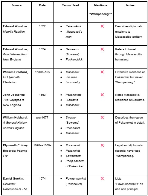
All the contemporary sources confirm the same thing. Accounts from seventeenth century explorers, settlers, governors, and historians—whether it be Thomas Dermer, Edward Winslow, William Bradford, Roger Williams. John Carver, John Winthrop, Steven Hopkins, Daniel Gookin, John Josselyn or William Hubbard—all confirm that Massasoit and his people identified exclusively as Pokanoket rather than Wampanoag.
Edward Winslow in Mourt’s Relations (1621) writes, “Tisquantum told us we should harley in one day reach Packonokick… From thence we went to Packonokick: but Massasoyt was not home.”[7]
In Hubbard’s History of New England it is stated that, “Massassoit … they brought down to the English at Plymith, though his place was at forty miles distance, called Swams, his country called Pokanoket.”[8]
Edward Winslow in Good News (1623) wrote, “I hired one to go with all expediency to reach Puckanokick … our turn from Sawaams, or Puckanokick.”[9]
John Josselyn in his Two Voyages (1663) documented that, “The Pokanokets live to the westward of Plimouth.’” He added, “Massasoit the great Sachem of the Plimouth Indians, his dwelling was at a place called Sowams.”[10]
In the second volume of the Plymouth Colony Records (1641), at page 23, Pocanacutt is mentioned as a country while in the fourth volume of Plymouth Colony Records (1662), there are several references to “Philip, Sachem of Pockanockett.”[11] Even the Minutes of The Commissioners of the United Colonies in September 1644 mention Poccanokick alias Sowamsett within notes of the meeting.[12] Then we have Daniel Gookin who was the Commissioner of the Praying Indians of Massachusetts Bay Colony and a colleague of the Puritan missionary John Eliot. His comprehensive accounts of New England’s Indigenous people are amongst the best of the early colonial period. Regarding the pre-colonial sachemships that existed prior to colonization (1620) he observed: “The principle nations of the Indians, that did, or do, inhabit within the confines of New England are five: 1: Pequots; 2. Narragansitts; 3. Pawkunnawkuts [Pokanokets]; 4. Massachsetts; and 5. Pawtucketts…”[13] No mention is made of the term “Wampanoag.”
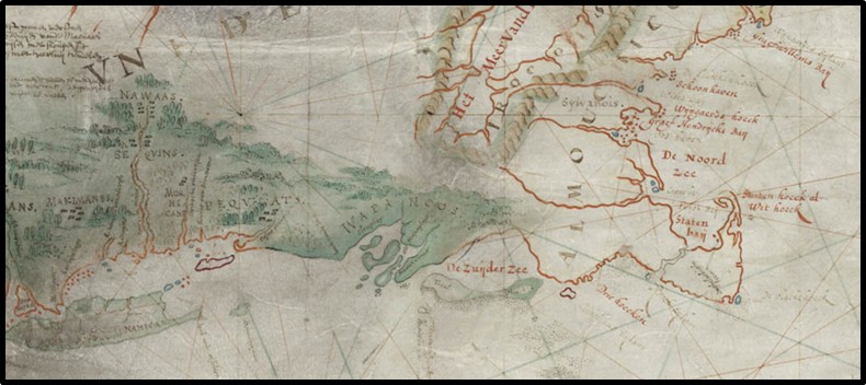
Further evidence is visually depicted in A Map of New England, By John Seller, Hydrographer to the King (1675), which was a map created by John Seller, a prominent English cartographer and hydrographer, around the late seventeenth century. This map is significant for its portrayal of New England during the early colonial period. It clearly depicts “Pokanoket Country” and “King Philip Country” in the land west of Plymouth colony as the images below indicate. Again, the term “Wampanoag” is not mentioned.
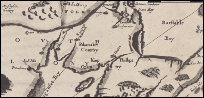
John Seller’s “A Map of New England” (1675) is one of the earliest English maps to depict the New England colonies in detail. It reflects both coastal geography and the English colonial ambitions of the seventeenth century. Published in London, the map emphasizes harbors, rivers, and European settlements. It also references Indigenous territories such as “Pokanoket Country,” which references served both navigational and political purposes, reinforcing English claims in the region during a time of growing colonial expansion and conflict, including King Philip’s War. It should be noted that even a historical map that serves colonial interests still acknowledges Pokanoket lands.
After examining these contemporary sources can it still be said with any degree of credibility that all of these colonial authors and cartographers were wrong? Did they all make the same mistake?
Perhaps the Indigenous accounts provide the insight that is further needed to clarify the confusion over the historic role of the Pokanoket. Nattawayhunt, sachem of the Quaboag Nipmucs, would have recognized the authority of the Pokanokets, especially given that one of his daughters was married to Massasoit Ousamequin. This kinship tie helps explain why Massasoit, “in his old age came hither, and was for a time ruling sachem at Quabaug” (present-day Brookfield, Massachusetts) in the late 1650s.[14] As his eldest son and heir, Wamsutta, assumed the responsibilities of leadership as the new Massasoit, while his father chose to spend his final years among his wife’s people.
In 1661, Uncas, sachem of the Mohegans, raided the Quaboag Nipmucs, killing, taking captives, and looting property despite their recognized alliance with Massasoit Osamequin and the Massachusetts colony. In response, Wamsutta, identified in colonial records as “sachem of Sowamsett,” a clear reference to the Pokanoket, asserted that the Quaboags were under his authority and declared he had waged war against Uncas that same summer.[15] The Massachusetts General Court backed Wamsutta’s claim and warned Uncas to cease hostilities or face military retaliation. While Pokanoket oral history attest that Wamsutta was successful in this military endeavor, no colonial document records a direct battle. However, Uncas’s raids ceased, and the Quaboags never submitted or paid tribute to the Mohegans. This strongly suggests that Massasoit Wamsutta successfully defended Pokanoket interests in the interior and that Uncas recognized the reach and resistance of Pokanoket leadership.
Chikataubut, sachem of the Massachusett, was a contemporary of Massasoit Ousamequin, the great sachem of the Pokanoket Confederacy. While each led distinct tribal groups, their appearance together in colonial records indicates a degree of diplomatic familiarity between the two. In March 1621, Massasoit signed a treaty with Plymouth Colony, pledging peace and mutual defense. Later that year, on September 13, Chikataubut joined eight other Indigenous leaders in signing the Instrument of Submission to King James I.[16] Massasoit did not attend, having already formalized relations with the colony, but one of his brothers, Quadequina, signed on his behalf. Chikataubut’s inclusion among the signers supports the view that he was one of the “confederates” Massasoit referred to earlier that year, reflecting a loose regional alliance shaped by shared interests in diplomacy and defense.
In 1621 and again in early 1622, Massasoit Ousamequin demonstrated his alliance with Plymouth Colony by warning Edward Winslow of a planned attack by the Massachusett, which involved Chikataubut’s people. These warnings not only helped the English avoid potential disaster but also revealed Massasoit’s political foresight and regional influence. His actions indicate that he actively monitored neighboring sachems and used diplomacy to strengthen his own position as a central figure in both intertribal and colonial affairs. It is therefore reasonable to presume that Chikataubut resented Massasoit Ousamequin after the events of 1622 and would not have forgotten how the Pokanokets had foiled his people’s plans.
The same could be said of Canonicus and Miantonomi of the Narragansetts. Historical records consistently show that the area now known as Barrington, Rhode Island, was referred to by both the Pokanokets and Narragansetts as Sowams (also spelled Sowamset), which was an Indigenous name that identified the region as a significant cultural and political center long before English colonization.[17] Even centuries later, Tecumseh, the great Shawnee leader who sought to forge a pan-Indian alliance to resist U.S. expansion across the Ohio River Valley, the Great Lakes, and beyond wrote of the Pokanokets:
“Where today are the Pequot? Where are the Narragansett, the Mohican, the Pokanoket, and other powerful tribes of our people? They have vanished before the avarice and oppression of the white man, as snow before the summer sun… Will we let ourselves be destroyed in our turn, without making an effort worthy of our race? Shall we without a struggle, give up our homes, our lands, bequeathed to us by the Great Spirit? The graves of our dead and everything that is dear and sacred to us? I know you will say with me, Never! Never!”[18]
Indigenous sources from the early seventeenth century and beyond indicate that Wampanoag was the incorrect terminology to use when describing the people who interacted with Plymouth colony in the 1620s. The inaccurate use of this term underscores the importance of reexamining early sources to disentangle historical truth from colonial reinterpretation.
An increasingly popular contemporary analogy is being incorporated today claiming that the Pokanoket was a village or location which in turn was part of a greater Wampanoag Confederation. If truth could be measured in mass appeal then this conclusion would be sound. However, from a historiographical lens the evidence does not support this thesis despite its general popularity. It is also incorrect for the same reasons that Wampanoag is not the correct terminology for the time period in question. Numerous Indigenous and early colonial sources, which I mention in this article, describe Pokanoket not merely as place or village, but as a distinct people and pre-colonial geopolitical entity. Even the word Pokanoket today is an anglicized version of the word whose meaning has been generalized for the convenience of English speaking authors who documented and categorized what they saw fit to record.
Colonial References to Massasoit’s People (Pre-1675). In all surviving 17th-century colonial records, Massasoit Ousamequin and his people were consistently referred to as the Pokanoket, the inhabitants of Sowams, or as Massasoit’s men. The term Wampanoag does not appear in any known English colonial document prior to the conflict known as the King Philip’s War in the 1670s.
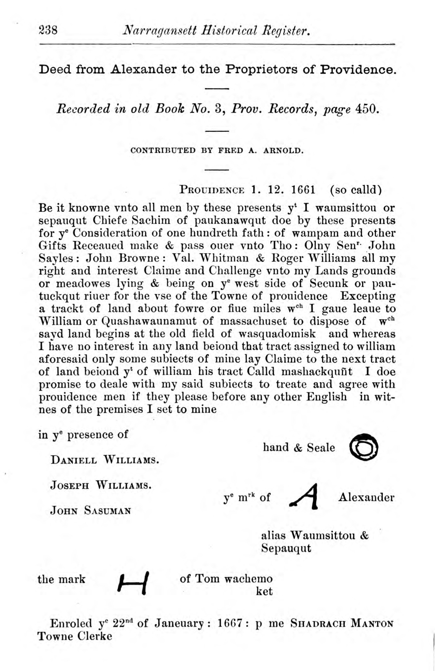
The modern borders of Providence, Rhode Island, do not reflect the Indigenous territorial divisions of the 17th century. At that time, the area was a contested between the Narragansett and Pokanoket. Natural features, particularly rivers and watersheds like the Mosshassuck (Moshoick) River served as key cultural and political boundaries. Land east of the river was claimed by the Pokanokets, while territory to the west was held by the Narragansetts. In 1638, Massasoit Ousamequin protested to Roger Williams that the Moshoick lands belonged to him and that he had never been conquered by the Narragansetts. The Narragansetts countered that after the devastating smallpox epidemic around 1619, which severely weakened the Pokanoket, Massasoit had submitted to their authority thus ceding the land to them. The conflict was formally resolved decades later, in 1661, when Massasoit’s son Wamsutta (also known as Alexander) signed a deed with Roger Williams and the settlers of Providence. In exchange for compensation, he acknowledged English settlement rights near the Moshoick River. The deed, in the second line, reads “Chief Sachim of Paukanawqut.” (Arnold, Narragansett Historical Register, vol. 4, 238)
Pokanoket: People, Place & Confederation: Linguistic Origins of “Wampanoag”
Now that we have established that the Pokanokets were the people who historically occupied the area of what would become Plymouth colony, the next topic to address is the origins of this term Wampanoag and how it is often conflated with the history of the Pokanokets. A review of the historical record demonstrates that there appears to be no credible evidence from any primary sources in which the term “Wampanoag” is given any notion of being a political or social organization until the start of King Philip’s War in 1675. However, there is evidence that within the correct historical context in pre-colonial southern New England, the use of the word “Wampanoag” was a simple linguistic term of reference having no distinct geographical or political connotations.
The Eastern Algonquian is a branch of the larger Algonquian language family that shares significant similarities due to their common ancestral roots. These languages were historically spoken by Indigenous peoples of what is now the northeastern regions of the United States and parts of eastern Canada. This includes the Massachusett, Narragansett, Mohegan, Pequot, Abenaki, Pennacook, and Pokanoket. It was commonly understood that the Indigenous people of southern New England spoke a similar dialect, that became more distinct the further one ventured from one tribal land to another.
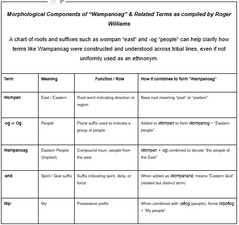
The core linguistic understanding of the term Wampanoag can be found in the research of academics, anthropologists, and scholars. Blair Rude’s “Raising Wampano from the Dead” asserted that the term Wampanoag is derived from the proto-Algonquian “wa-panwi,” which translates into “it dawns,” which has the connotation of “easterner.”[19] Ives Goddard comes to a similar conclusion in his research that Wampanoag was specifically derived from the proto- Eastern Algonquian word “Wapanoo”, the Munsee Delaware word for “easterner.”[20] Thus, it can be understood that the term “Wampanoag” was a local variation of “easterner” used amongst the Eastern Algonquian-speaking tribes of eastern New York, Massachusetts, and Connecticut.
In the writings of Roger Williams, who spent considerable time with the Narragansett documenting their language, customs, and beliefs, we find references that further support the geographic meaning of the term “Wampanoag.” Notably, Williams makes no mention of Wampanoag as the name of a distinct tribal group, even though the Narragansett were the political and territorial rivals of Massasoit Ousamequin, the leader of the Pokanoket. This absence is striking and indicates that the term “Wampanoag” was not used by the Narragansett to refer to their neighbors, the Pokanokets. What Williams does record is the term Wampanand, meaning “Eastern God,” a derivative of Wompan or “east.”[21] This linguistic evidence supports the conclusion that while Wampanoag was not an Indigenous term or identity used for a specific tribe, a Narragansett speaker would have recognized its meaning based on the shared Eastern Algonquian linguistic structure.
Indeed, variations of the word Wampanoag can be found in dialects of Indigenous people from Delaware all the way to Maine. Variations of this term depended upon the dialect and geographic location of these people. They are referenced by European explorers navigating the area in the seventeenth century.[22] Some of the names include (woban) “daybreak,” (aki) “land,” Wobanaki (ag), “Easterner” (from where the daylight comes).[23] Other variations include Wobanakkiak, Wabanaki, and Wapanacki, with the Natick word for full day light being “wompan.” All share linguistic roots to the term Wampanoag. Furthermore, it is important to note that “Wabanaki” and “Abanaki” are a distinct Indigenous people of the Northeast whose historic homelands include what is now Maine, parts of northern New Hampshire, and parts of Quebec Province. No comparable documentary or structural evidence exists to support the use of the term “Wampanoag” as a unified people or polity in southern New England during the seventeenth century.[24]
The English were not the only European explorers to survey this area. The Dutch from New Amsterdam (New York) navigated through the Hudson and Quinnipiac rivers and made their way into Narragansett Bay, eager to gain an advantage in the fur trade. One Dutch explorer, Adriaen (also spelled Adrian) Block, was notable for his explorations of the northeastern coast of North America in the early seventeenth century. In The Figurate Map of Adrian Block (1614), the name “Wampanoos” is drawn over an area east of the “Pequats” (Narragansett Bay) as if the Dutch explorer was under the impression that all the tribes beyond this point were “easterners.”[25] This is likely due to the fact that Block’s Indigenous guides were not native to the region and thus used the term “Wampanoos” or “easterner” to designate the tribes that inhabited the area around Narragansett Bay.
Figurative Map of Adrian Block (1614). Adriaen Block’s 1614 “Block Chart,” submitted to the Dutch States-General alongside trade petitions, served both as a navigational aid and a political instrument to assert Dutch claims in New Netherland (Nieu Nederlandt). It is the earliest known map to depict Long Island and Manhattan as islands and to outline key coastal features such as Long Island Sound and the Connecticut River. Notably, it labels the Pequats and, to their east, the “Wampanoos,” a geographic term meaning “easterners” in the Algonquian language. (“Adriaen Block’s 1614 Map of Long Island Sound and the Connecticut River,” Colonial Wars of Connecticut, accessed February 21, 2025, https://www.colonialwarsct.org/1614.htm?utm_source=chatgpt.com, accessed Feb. 21, 2025)
Interpretations of Block’s explorations have led some to believe there is evidence of “Wampanoag” being used to describe a tribe. Yet in such studies of early colonial cartography and Indigenous history, small editorial decisions can have outsized consequences. One such example lies in the interpretation of Johan de Laet’s Nieuwe Wereldt (1625), a seminal Dutch account of the geography and Indigenous peoples of northeastern North America. In the 1909 English edition Narratives of New Netherland, 1609–1664, historian J. Franklin Jameson made a crucial and revealing interpretive choice by replacing Johan de Laet’s Dutch references to the “Narragansetts” and the tribe east of them called the “Horicans” as “Narragansetts” and “Wabankis,” respectively, thereby introducing the northern Wabanaki Confederacy into a geographic context where it did not belong onto groups who never belonged to it.[26] Jameson’s decision reflects the approach of many nineteenth and early twentieth century scholars who assumed that Wampanoag was the correct designation and routinely replaced or “corrected” what they perceived as errors in earlier sources. This underscores a broader problem in historical scholarship as editorial interventions are never neutral and can shape public understanding for generations.
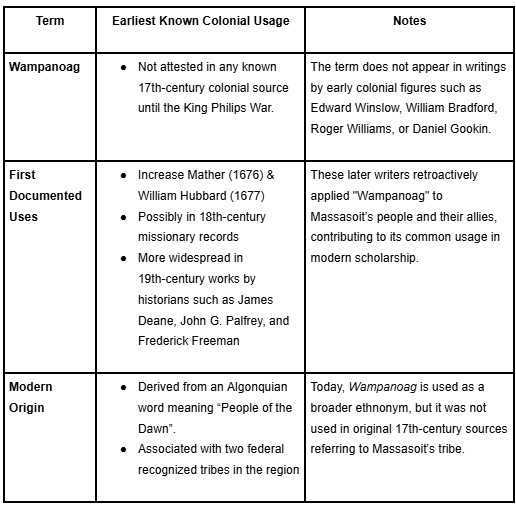
17th and 18th Century Use of the Term Wampanoag. Early writers and officials such as Edward Winslow, William Bradford, John Josselyn, and Daniel Gookin referenced the Pokanoket by their regional or political identity, frequently naming their homeland of Sowams or their leader Massasoit. Gookin, writing as late as 1674, includes the “Pawkunnawkuts” (Pokanokets) as one of the five principal nations of New England, yet makes no mention of “Wampanoag.” The term Wampanoag, meaning “People of the Dawn” in Algonquian, only came into regular usage in the 18th and 19th centuries, particularly through missionary records, ethnographic studies, and antiquarian histories. As such, it is a post-colonial label retroactively applied to a broader grouping of Indigenous communities, but it was not the name by which Massasoit’s people were known among themselves or to early English settlers during the time of first contact.
Seventeenth and Eighteenth Century Use of the Term Wampanoag
The origins of the term “Horicans” illustrate how fluid and inconsistent early European spellings could be. As E. M. Ruttenber notes in Footprints of the Red Men (1906):
“Horikans was written by De Laet, in 1624, as the name of an Indian tribe living at the head waters of the Connecticut. On an ancient map Horicans is written in Lat. 41, east of the Narragansetts… Moricans is written west of the Connecticut, and Horikans on the upper Connecticut in latitude 42. Morhicans is the form on Carte Figurative of 1614–16, and Mahicans by the Dutch on the Hudson … The several forms indicate that the tribe was the Moricans or Mourigans of the French, the Maikans or Mahikans of the Dutch and the Mohegans of the English.”[27]
In short, the “Horicans” were not a separate tribe at all, but simply different spellings for the Mahican or Mohegan peoples who lived along the Hudson and Connecticut River valleys. Most importantly, they were not “Wampanoag.”
Further linguistic evidence similarly demonstrates how European writers often collapsed unique Algonquian distinctions into oversimplified forms. E. M. Ruttenber noted that Wompompeag was an early Mohegan term from which the word “wampum” developed, and Roger Williams likewise explained that wompom meant “white,” referring to the white shell beads used in diplomacy and trade. Ruttenber also cited the Deed of July 11, 1661, in which the place name Wompenanit appears to describe “the utmost end eastward” of the Montauk Peninsula, what we now call Montauk Point on Long Island in present day New York State.[28] The derivatives of –wompi (white, bright, daylight) and -anit (“to be more than”) signified not only the farthest geographic east but also cosmological concepts of light, the east, and spiritual power.[29] These terms demonstrate that what the English would later generalize as “Wampanoag” (“easterners”) was in fact part of a larger Algonquian pattern of geographic locative and cosmological naming.
King Philip War and its Wampanoag Legacy
By the late seventeenth century, during and after King Philip’s War (Metacom’s War), the term had become standardized as “Wampanoag,” a usage reinforced in part by western tribes allied with the English, who applied it to describe their eastern neighbors.[30] The term was likely introduced into English by Mohegan and Pequot allies, who fought alongside colonial forces and used it as an outsider’s name for the more distant easterly Algonquian speaking tribes, such as the Pokanoket. English soldiers and writers, unfamiliar with the internal distinctions amongst Indigenous groups, adopted “Wampanoag” as a convenient label for all Indigenous forces aligned with Philip.
Over time, colonial authorities and writers began applying the term more broadly to describe the various Algonquian-speaking groups inhabiting southeastern Massachusetts and Rhode Island. Importantly, these Indigenous guides were correct because from their perspective, those Algonquian-speaking peoples to the east could rightly be called “easterners.” But then the term “Wampanoag” was effortlessly misappropriated from its original definition as a generalized descriptive geographic term to a designation of a political body.
The meaning of Wampanoag shifted dramatically during King Philip’s War (1675–1678). While the Great Dying had already cleared the way for English colonization in southern New England, it was this conflict that secured English dominance at the expense of the region’s free and independent Indigenous nations. The war marked an epochal turning point, including by creating the conditions for the misappropriation of “Wampanoag” as a tribal name. Before the war, colonial sources consistently referred to Indigenous people as Pokanoket, “Massasoit’s people,” or by the names of individual sachemships or settlements such as Nemasket and Sakonnet. During and after the war, however, English chroniclers increasingly employed “Wampanoag” as a blanket designation, sometimes applying it broadly to all Algonquian groups east of the Narragansetts. In this way, “Wampanoag” hardened in the colonial vocabulary as the collective name for the various Indigenous peoples who rallied under Massasoit Metacom (called King Philip by the English) banner, even though in his own signatures in treaties and land deeds he continued to identify himself as Pokanoket.[31]
Captain James Oliver’s account of the Great Swamp campaign (1675) and Increase Mather’s A Brief History of the War with the Indians in New England (1676) both employ “Wampanoag” or its variants to describe their enemy.[32] Yet, notably, William Hubbard, writing just a year later in his Narrative of the Indian Wars in New-England (1677), reverted to calling Metacom (King Philip) both the “Sachem of Mount-Hope” and “chief Sachem of Pokanoket.”[33] But most writers followed Oliver and Mather. In this sense, “Wampanoag” emerged as a wartime colonial construct, a term that entered the English colonial vocabulary usage amid the turmoil of King Philip’s War. This reclassification supplanted the intricate kinship networks, settlements, and territorial identities by which the Indigenous peoples of southern New England had long defined their distinct polities in the seventeenth century.[34]
Words, like the peoples and cultures they represent, can change over time, and “Wampanoag” is a prime example of this shift. Its historical connotation transformed at the onset of King Philip’s War, a conflict that determined the fate of both the Indigenous peoples and the New England colonies and, by extension, the future United States. During this period, the term “Wampanoag” began to take on new meaning, and this transformation was largely driven by the English colonizers rather than by the Indigenous peoples themselves. While much academic scholarship has focused on the significance of this war, it remains underappreciated in the public narrative, which often reduces it to a simple conflict between Indigenous peoples and settlers.
In fact, the colonists were not fighting a unified coalition of all the Indigenous nations of New England. Prior to the outbreak of the war in 1675, a number of Indigenous tribes and communities had sought protection from the English and chose not to fight against them in the conflict. These groups included the Nausett, Poamett, Mannamoiicke, Wequchutt, Ashemiutt, Sakatuckett, Nobscussett, Mattakeesett, Mannomett, Caukochise, and Masphee.[35] Other tribes made the decision to remain neutral, side with the English, or oppose the conflict for reasons specific to their own interests.[36] The conflict involved separate factions of Indigenous people from Narragansett, Nipmuc, and Mohegan, to the remnants of the Pokanoket Confederation and the Praying Indian communities along eastern Massachusetts. During the war, acts of inhuman treatment became common, and often the colonists did not distinguish between Indigenous peoples who fought with Metacom (King Philip) and those who remained neutral or fought alongside the English. The violence of the conflict blurred the lines of morality, leaving lasting scars on both the Indigenous communities and the colonial settlers.
Political Identity and Modern Implications
While the history of King Philip’s War is well-documented, it is crucial to recognize the deep fear and intense hatred that the colonists harbored toward the Pokanoket people, that is, King Philip’s people. The Pokanokets were blamed by the English for sparking the conflict, and as a result, they were subjected to damnatio memoriae, the condemnation of their memory by the victors. This colonial practice of name suppression had precedent. Following the Pequot War (1636–1637), the 1638 Treaty of Hartford formally outlawed the use of the Pequot name, declaring, “The Pequots shall no more be called Pequots but Narragansetts and Mohegans.”[37]
Many of the Pokanoket warriors who fell into colonial hands during King Philip’s War were executed, while others were sold into slavery and transported to the Caribbean and Iberia.[38] Those who escaped the jaws of death were embraced by the cold arms of enslavement and indentured servitude across seas and oceans. Surviving women and children were likewise bound into servitude or exile, as court records in Plymouth detail.[39] Contemporary accounts by Increase Mather and William Hubbard emphasize the executions and the widespread dispersal of captives, while Jill Lepore has shown how this policy targeted Philip’s own people in particular, reducing the Pokanokets to a remnant scattered across the Atlantic world.[40] In the aftermath, as Daniel Gookin observed, Pokanoket survivors were absorbed into neighboring communities including the Nipmuc, and Niantic-Narragansetts or fled north into Abenaki country, scattering the people once united under Massasoit’s Metacoms (King Philip) authority.[41] A geographic term replaced their political identities, not out of choice but out of sheer desperation as the scattered and vulnerable Indigenous communities struggled to endure. This shift was a direct consequence of settler colonialism and survival under duress.
During and after the war, the term Wampanoag became a label used by English colonists and later historians to describe an aggregate of various Indigenous groups, such as the Pokanoket, Massachusetts, Narragansett, Nipmuc, and others whom Massasoit Metacom (alias King Philip) sought to unite under his leadership.[42] Coined by the English during the war, Wampanoag evolved into a generalized term that not only referred to those who fought against the English but also, over time as memories of the past blended into stories told to surviving generations, it became synonymous with the Indigenous peoples of southern New England. As W. F. Gookin aptly noted regarding this transformation, “It is one of the ironies of history that the most easterly of them, the Christian Indians of the Cape and the Islands, are now also known by the name [Wampanoag] used for the tribes that refused to aid [King Philip] in 1675.”[43]
It was not until nearly 300 years later, in 1928, that Indigenous communities including Mashpee, Gay Head (Aquinnah), Herring Pond, and Assonet, reorganized under the renewed political identity of the Wampanoag Nation. The “Wampanoag Nation” that reorganized in 1928 represents a post-contact political identity. Seventeenth century sources consistently identify Massasoit Ousamequin’s people as Pokanoket. Its adoption in the twentieth century as the “Wampanoag Nation” reflects Indigenous survival and political reorganization in the face of colonial erasure, rather than continuity with seventeenth century self-identification.[44] It is crucial to distinguish between the term Wampanoag as it was used in 1620, 1675 and its later political meaning in 1928. In the early seventeenth century, Massasoit Ousamequin, his people, the surrounding Indigenous nations, and the first generation of English settlers all understood who the Pokanokets were.
In conclusion, the historical evidence establishes that the tribe that “greeted the Pilgrims” in 1621 identified as “Pokanoket,” not “Wampanoag.” While the term “Wampanoag” has become a dominant label in contemporary discourse, it is a colonial construct that has obscured the true names and identities of the Indigenous peoples of southern New England. Understanding and respecting these distinctions is essential to acknowledging the complex and often painful history of colonization. While this information may be new to some, one must understand that in historiography when the evidence changes, so must the thesis. To ignore the “veto power” of primary sources and accept popular contemporary narratives without question is irresponsible and dangerously ahistorical. For these reasons today, there remains widespread confusion about the histories of the Pokanoket and the Wampanoag.
Indigenous people in southern New England too must recognize the necessity of decolonizing our minds and reclaiming the names of our ancestors, rather than accepting the terms imposed upon them by their colonizers. Before we were Wampanoag, we were Pocasset, Sakonnet, Nemasket, Chappaquiddick, Manomet, Saukatucket, Pokanoket, and we still are. We hold on to the name and identity of the people who welcomed strangers to our shores. And when these strangers became conquerors, we continued to hold onto our name for generations in defiance. The Pokanokets are still here, and so long as our people remember who we are, we can never truly be conquered, and our story will never be erased from the pages of history.
Notes:
[1] W. F. Gookin, “Massasoit’s Domain: Is ‘Wampanoag’ the Correct Designation?” Bulletin of the Massachusetts Archaeological Society 20, no. 1 (1958): 12. [2] Edward Winslow, Good Newes from New England (London: William Jones, 1624), 62-63, https://www.gutenberg.org/cache/epub/66332/pg66332-images.html, accessed Dec. 4, 2024. [3] Rehoboth North Purchase, 1641 and Taunton North Purchase, 1649, in Jeremy Dupertuis Bangs, Indian Deeds: Land Transactions in Plymouth Colony, 1620–1691 (Cambridge, MA: General Society of Mayflower Descendants, 2002); Nathaniel Morton, New England’s Memorial (Cambridge, MA: S.G. and M.J., 1669), 80–83; Samuel Hopkins Emery, The History of Taunton, Massachusetts (Syracuse, NY: D. Mason & Co., 1893), 31–32; John Daggett, A Sketch of the History of Attleborough (Attleborough, MA: John S. Daggett, 1894), 5–7; John Daggett, History of Norton, Massachusetts (Norton, MA: John Daggett, 1837), 4–6; Thomas W. Bicknell, A History of Barrington, Rhode Island (Providence: Snow & Farnham, 1898), 30–34; Daniel Gookin, Historical Collections of the Indians in New England (Cambridge, MA: Samuel Green, 1674), 12–13; Colin G. Calloway, New Worlds for All: Indians, Europeans, and the Remaking of Early America (Boston: Bedford/St. Martin’s, 1997). [4] Thomas Dermer, Letter of Thomas Dermer: Describing His Passage from Maine to Virginia, A.D. 1619 (New York: [s.n.], 1841), 350, http://hdl.loc.gov/loc.gdc/gckb.010, accessed May 10, 2024. [5] William Bradford and Edward Winslow, Mourt’s Relation: A Journal of the Pilgrims at Plymouth, 1622. Part I, ed. Dwight B. Heath (New York: The New York Public Library, 1963; The Plymouth Colony Archive Project, 2007), 59, http://www.histarch.illinois.edu/plymouth/mourt1.html, accessed May 1, 2025. [6] Edward Winslow, Good Newes from New England (London: William Jones, 1624), 62-63, https://www.gutenberg.org/cache/epub/66332/pg66332-images.html, accessed May 10, 2024. [7] Ibid. [8] Rev. William Hubbard, A General History of New England from the Discovery to MDCLXXX (Boston: Charles C. Little and James Brown, 1848), as quoted in Thomas Williams Bicknell, A History of Barrington, Rhode Island (Providence: Snow & Farnham, 1898), 97. [9] Gookin, “Massasoit’s Domain: Is ‘Wampanoag’ the Correct Designation?,” 13. [10] John Josselyn, “An Account of Two Voyages to New-England Made During the Years 1638, 1663,” ed. William Veazie (Project Gutenberg, 2022), https://www.gutenberg.org/files/66922/66922-h/66922-h.htm, accessed July 1, 2024. [11] Gookin, “Massasoit’s Domain: Is ‘Wampanoag’ the Correct Designation?,” 13. [12] Ibid. [13] Gookin, Historical Collections of the Indians in New England (Cambridge, MA: The Prince Society, 1866). [14] J. H. Temple, History of North Brookfield, Massachusetts: Preceded by an Account of Old Quabaug, Indian and English Occupation, 1647–1676 (North Brookfield, MA: Town of North Brookfield, 1887), 23. [15] Ibid., 44–46. [16] The Compact with the Charter and Laws of the Colony of New Plymouth, ed. William Brigham (Boston: Dutton and Wentworth, 1836), 111–112, https://quod.lib.umich.edu/cgi/t/text/text-idx?cc=evans;idno=N03341.0001.001;node=N03341.0001.001:11;rgn=div1;view=text, accessed May 1, 2025. [17] Rhode Island Historical Preservation & Heritage Commission, Historic and Architectural Resources of Barrington, Rhode Island: A Preliminary Report (Providence: Rhode Island Historical Preservation Commission, 1993), 5. [18] Dee Brown, Bury My Heart at Wounded Knee: An Indian History of the American West (New York: Henry Holt and Company, 2007), 1. [19] Blair Rudes, “Resurrecting Wampano (Quiripi) from the Dead: Phonological Preliminaries,” Anthropological Linguistics 39, no. 1 (Spring 1997): 4. [20] Ives Goddard, “The Ethnohistoric Implications of Early Delaware Linguistic Materials,” Man in the Northeast 1 (1971): 14-26. [21] Roger Williams, A Key into the Language of America: Or, an Help to the Language of the Natives in That Part of America Called New-England (London: Gregory Dexter, 1643), 116. [22] Ives Goddard, “Eastern Algonquian Languages,” in Handbook of North American Indians, vol. 15, Northeast, ed. Bruce G. Trigger (Washington, DC: Smithsonian Institution, 1978), 70–77; Ives Goddard, “The Use of Exonyms in Algonquian Language Contact,” International Journal of American Linguistics 52, no. 3 (1986): 361–63; Rudes, “Resurrecting Wampano,” in Papers of the Twenty-Ninth Algonquian Conference, ed. Pentland, 268–69; John Eliot, The Indian Grammar Begun (Cambridge, MA: Marmaduke Johnson, 1666), introduction; William Wood, New England’s Prospect (London: John Dawson, 1634), 74-76. [23] Gookin, “Massasoit’s Domain: Is ‘Wampanoag’ the Correct Designation?,” 14. [24] Sylvia Kasprycki, “Ethnic Names and Identities: The Case of the Abenaki,” Anthropos 97, no. 1 (2002): 115–27; Colin G. Calloway, The Western Abenakis of Vermont, 1600–1800 (Norman: University of Oklahoma Press, 1990); Emma Anderson, The People of the Dawn: The Wabanaki Confederacy (Toronto: University of Toronto Press, 1999); Harold Prins, “Children of Gluskap: Wabanaki Indians on the Eve of the European Invasion,” in American Beginnings: Exploration, Culture, and Cartography in the Land of Norumbega, ed. Emerson W. Baker, Edwin A. Churchill, Richard D’Abate, Kristine L. Jones, Victor A. Konrad, and Harald E. L. Prins (Lincoln: University of Nebraska Press, 1994), 85–102. [25] Gookin, “Massasoit’s Domain: Is ‘Wampanoag’ the Correct Designation?,” 14. [26] J. Franklin Jameson, ed., Narratives of New Netherland, 1609–1664 (New York: Charles Scribner’s Sons, 1909), 77–78. [27] E. M. Ruttenber, Footprints of the Red Men: Indian Geographical Names in the Valley of Hudson’s River, the Valley of the Mohawk, and on the Delaware (Albany, NY: New York State Education Department, 1906), 236–37. [28] Ibid.; Williams, A Key into the Language of America, 165–66; J. Hammond Trumbull, The Composition of Indian Geographical Names (Hartford: Case, Lockwood & Brainard, 1870), 24–25; William Wallace Tooker, Indian Place-Names on Long Island and Islands Adjacent (New York: Putnam’s, 1911), 250–51; “Deed of July 11, 1661,” in E. B. O’Callaghan, ed., The Documentary History of the State of New York, vol. 1 (Albany: Weed, Parsons, 1849), 763. [29] Ruttenber, Indian Geographical Names in the Valley of Hudson’s River, the Valley of the Mohawk, and on the Delaware, 236–37; Trumbull, The Composition of Indian Geographical Names, 24–25; William Wallace Tooker, Indian Place-Names on Long Island and Islands Adjacent (New York: Putnam’s, 1911), 250–51; Williams, A Key into the Language of America, 165–66. [30] Lincoln Newton Kinnicutt, Indian Names of Places in Plymouth, Middleborough, Lakeville and Carver, Plymouth County, Massachusetts: With Interpretations of Some of Them (Worcester, MA: Commonwealth Press, 1909), 36. [31] William Hubbard, The Present State of New England (London: Thomas Parkhurst, 1677), 23–25; Increase Mather, A Brief History of the War with the Indians in New-England (Boston: John Foster, 1676), 5–7; Records of the Colony of New Plymouth in New England, ed. Nathaniel B. Shurtleff and David Pulsifer, vol. 5 (Boston: William White, 1856), 251–52; Ives Goddard, “The Use of Exonyms in Algonquian Language Contact,” International Journal of American Linguistics 52, no. 3 (1986): 361–63; Rudes, “Resurrecting Wampano,” in Papers of the Twenty-Ninth Algonquian Conference, ed. Pentland, 268–69; Jill Lepore, The Name of War: King Philip’s War and the Origins of American Identity (New York: Vintage, 1998), 22–24; Jean M. O’Brien, Firsting and Lasting: Writing Indians Out of Existence in New England (Minneapolis: University of Minnesota Press, 2010), 45–47. [32] Captain James Oliver, “Letter to Governor Leverett,” December 27, 1675, in The Colonial Records of Massachusetts, vol. 5 (Boston, 1856), 56–58; Mather, A Brief History of the War with the Indians, 6–7. [33] William Hubbard, A Narrative of the Indian Wars in New-England (Boston, 1677), 45-52. [34] Kathleen J. Bragdon, Native People of Southern New England, 1500–1650 (Norman: University of Oklahoma Press, 1996), 13–14; Daniel R. Mandell, King Philip’s War: Colonial Expansion, Native Resistance, and the End of Indian Sovereignty (Baltimore: Johns Hopkins University Press, 2010), 8–10; Neal Salisbury, Manitou and Providence: Indians, Europeans, and the Making of New England, 1500–1643 (New York: Oxford University Press, 1982), 141–42. [35] John G. Erhardt, The History of Rehoboth, Seekonk, East Providence, Pawtucket, & Barrington, vol. 2, Seacunke 1645–1692 (Seekonk, MA: J. G. Erhardt, 1983), 238. [36] Mather, A Brief History of the War, 12–14; Hubbard, A Narrative of the Troubles with the Indians, 25–27; Records of the Colony of New Plymouth, eds. Shurtleff and Pulsifer, vol. 5, 252–53; Lepore, The Name of War, 75–80; Yasuhide Kawashima, Igniting King Philip’s War: The John Sassamon Murder Trial (Lawrence: University Press of Kansas, 2001), 130–35; Mandell, King Philip’s War, 83–90. One author claims that that the Niantic sachem Ninigret demonstrated his loyalty to the English by agreeing to surrender “such Pokanoket refugees as might be found in his territories.” Samuel G. Drake, Indian Biographies, vol. 1 (Boston: Antiquarian Institute, 1836), 235-36. [37] Hubbard, The Present State of New England, 23–25; Mather, A Brief History of the War with the Indians, 5–7; Records of the Colony of New Plymouth, eds. Shurtleff and Pulsifer, vol. 5, 251–52; Lepore, The Name of War, 3–6, 143–47; “Treaty of Hartford, 1638,” in Charles J. Hoadly, ed., Records of the Colony and Plantation of New Haven, from 1638 to 1649 (Hartford: Case, Tiffany & Co., 1857), 29; John Mason, A Brief History of the Pequot War (Boston: S. Kneeland & T. Green, 1736), 27–30; Alfred A. Cave, The Pequot War (Amherst: University of Massachusetts Press, 1996), 156–59; Jean M. O’Brien, Firsting and Lasting: Writing Indians Out of Existence in New England (Minneapolis: University of Minnesota Press, 2010), 45–47; Goddard, “The Use of Exonyms in Algonquian Language Contact,” 361–63; Rudes, “Resurrecting Wampano,” in Papers of the Twenty-Ninth Algonquian Conference, ed. Pentland, 268–69. [38] Mather, A Brief History of the War with the Indians, 7–9. [39] Records of the Colony of New Plymouth, eds. Shurtleff and Pulsifer, vol. 5, 251–53. [40] Mather, A Brief History of the War with the Indians, 7–9; Hubbard, A Narrative of the Troubles with the Indians, 44–46; Jill Lepore, The Name of War, 142–47. [41] Gookin, Historical Collections of the Indians in New England, 12–13. [42] Ibid., 14. [43] Ibid. [44] Edward Winslow, Good News from New England (London: William Bladen, 1624), 20; Lepore, The Name of War, 142–47; O’Brien, Firsting and Lasting, 45–47.The Author
You Might Also Like


